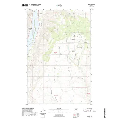
2020 Map of Orondo
USGS Topo · Published 2020About this map
Lake Entiat serves as the focal point for this section of the Columbia River valley, where the borders of Chelan Co and Douglas Co meet. The settlement of Orondo sits near the river's edge, characterized by a network of rural roads such as Rainbow Ln and Rocky Rd E that navigate the rising elevations of the valley walls. Across the water, Wagnersburg marks the western bank, while the landscape to the east climbs significantly toward the heights of Badger Mtn and the topographical complexity of McGinnis Canyon. Rural life in this part of Washington is further evidenced by the secluded South Side Cem and the drainage patterns of Beaver Cr and Rock Island Cr. The naming of modern thoroughfares like Mule Deer Rd and Wild Turkey Rd suggests the enduring character of the local environment and its wildlife.
Find a feature on this map
58 named features on this map. Tap any name to fly to it.
Don’t see what you’re looking for? This feature index may not catch every label — zoom into the map to look around manually.
Map Details
Editions of this 2020 Orondo Map
This is the sole edition of this map. No revisions or reprints were ever made.
Other maps of this area

1901 · Chelan
USGS Topo · 1:125,000

1912 · Malaga
USGS Topo · 1:48,000

1913 · Wenatchee
USGS Topo · 1:62,500

1914 · Malaga
USGS Topo · 1:62,500

1915 · Wenatchee
USGS Topo · 1:62,500

1920 · Colockum Pass
USGS Topo · 1:125,000

1922 · Colockum Pass
USGS Topo · 1:125,000

1957 · Wenatchee
USGS Topo · 1:250,000
1966 · Malaga NE
USGS Topo · 1:24,000

1966 · Rock Island
USGS Topo · 1:24,000