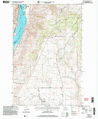
2003 Map of Orondo
USGS Topo · Published 2006About this map
Lake Entiat and the Columbia River dominate the western edge of this landscape, marking the boundary between Chelan and Douglas counties. The settlement of Orondo serves as a local hub near the river, supported by a network of Pumping Stations and agrarian infrastructure like Storage Bins. The terrain rises sharply to the east toward the expansive heights of Badger Mountain, where the Badger Mtn Lookout and a Communication Tower emphasize the ridge's strategic elevation.
Find a feature on this map
24 named features on this map. Tap any name to fly to it.
Don’t see what you’re looking for? This feature index may not catch every label — zoom into the map to look around manually.
Map Details
Editions of this 2003 Orondo Map
This is the sole edition of this map. No revisions or reprints were ever made.
Other maps of this area

1901 · Chelan
USGS Topo · 1:125,000

1912 · Malaga
USGS Topo · 1:48,000

1913 · Wenatchee
USGS Topo · 1:62,500

1914 · Malaga
USGS Topo · 1:62,500

1915 · Wenatchee
USGS Topo · 1:62,500

1920 · Colockum Pass
USGS Topo · 1:125,000

1922 · Colockum Pass
USGS Topo · 1:125,000

1957 · Wenatchee
USGS Topo · 1:250,000
1966 · Malaga NE
USGS Topo · 1:24,000

1966 · Rock Island
USGS Topo · 1:24,000