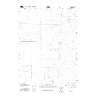
2011 Map of Orovada
USGS Topo · Published 2011About this map
The high desert agriculture of the Quinn River Valley defines this 2011 survey of northern Nevada. At the center of this landscape sits Orovada, where the Orovada Post Office serves a community anchored by dispersed homesteads and aviation at the Pine Grove Airport. The settlement pattern reflects the enduring importance of ranching in Humboldt County, marked by established operations such as Rebel Creek Ranch, Golden Acres Ranch, and Buffalo Ranch. Water management is evident through a network of drainages descending from the heights of Sawtooth Mountain to the east, including Rebel Creek and Antelope Creek. Historically significant routes like Old Hwy 95 and Rebel Cr Rd provide the primary infrastructure through these wide basins, connecting remote family-named landmarks like Buffalo Meadows and the Rebel Creek Post Office to the regional grid.
Find a feature on this map
39 named features on this map. Tap any name to fly to it.
Don’t see what you’re looking for? This feature index may not catch every label — zoom into the map to look around manually.
Map Details
Editions of this 2011 Orovada Map
This is the sole edition of this map. No revisions or reprints were ever made.
Other maps of this area

1882 · Paradise
USGS Topo · 1:250,000

1893 · Paradise
USGS Topo · 1:250,000

1955 · McDermitt
USGS Topo · 1:250,000

1958 · Paradise Valley
USGS Topo · 1:62,500

1958 · Awakening Peak
USGS Topo · 1:62,500

1959 · McDermitt
USGS Topo · 1:250,000

1959 · Orovada
USGS Topo · 1:62,500

1959 · Hinkey Summit
USGS Topo · 1:62,500
1982 · Andorno Ranch
USGS Topo · 1:24,000
1982 · Gallagher Flat
USGS Topo · 1:24,000