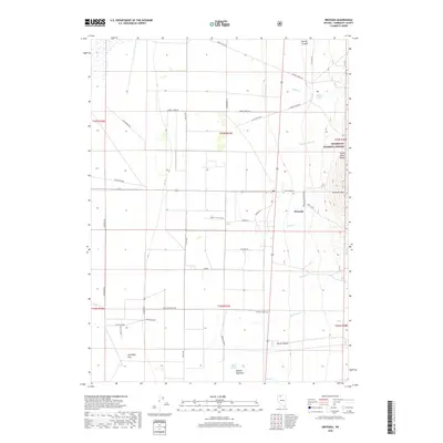
2018 Map of Orovada
USGS Topo · Published 2018About this map
Orovada sits at the base of the Santa Rosa Range in this modern survey of Humboldt County, Nevada. The landscape is defined by the sharp transition from the irrigated ranch lands and wide basins of Gallagher Flat to the steep eastern terrain of the Humboldt National Forest. Water management is central to life here, with numerous mountain streams like Rebel Cr, Rock Cr, and McConnell Cr flowing down toward the valley floor, supporting agricultural operations along Buffalo Ranch and nearby Buffalo Meadows. A dense network of local roads and lanes, including Kings River Rd and Mike & Julie Key Rd, reveals the pattern of contemporary rural settlement. Notable peaks like Sawtooth Mtn dominate the eastern skyline, providing a backdrop to the springs and canyons that have sustained this high-desert community for generations.
Find a feature on this map
46 named features on this map. Tap any name to fly to it.
Don’t see what you’re looking for? This feature index may not catch every label — zoom into the map to look around manually.
Map Details
Editions of this 2018 Orovada Map
This is the sole edition of this map. No revisions or reprints were ever made.
Other maps of this area

1882 · Paradise
USGS Topo · 1:250,000

1893 · Paradise
USGS Topo · 1:250,000

1955 · McDermitt
USGS Topo · 1:250,000

1958 · Paradise Valley
USGS Topo · 1:62,500

1958 · Awakening Peak
USGS Topo · 1:62,500

1959 · McDermitt
USGS Topo · 1:250,000

1959 · Orovada
USGS Topo · 1:62,500

1959 · Hinkey Summit
USGS Topo · 1:62,500
1982 · Andorno Ranch
USGS Topo · 1:24,000
1982 · Gallagher Flat
USGS Topo · 1:24,000