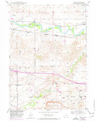
1949 Map of Orpha
USGS Topo · Published 1977About this map
The North Platte River defines the northern landscape of this Wyoming region, where the Chicago and Northwestern and Burlington Northern railroads trace the river valley near the small settlement of Orpha. This mid-century survey documents a land transitioning from frontier history to twentieth-century irrigation, marked prominently by the Fort Fetterman Reservation Boundary and the Oregon Trail Monument near Alkali Gulch.
Find a feature on this map
29 named features on this map. Tap any name to fly to it.
Don’t see what you’re looking for? This feature index may not catch every label — zoom into the map to look around manually.
Map Details
Editions of this 1949 Orpha Map
2 editions found
Other maps of this area

1949 · Sundquist Ranch
USGS Topo · 1:24,000

1949 · Orpha
USGS Topo · 1:24,000

1949 · Careyhurst
USGS Topo · 1:24,000

1949 · Gilbert Lake
USGS Topo · 1:24,000

1949 · Douglas
USGS Topo · 1:24,000

1949 · Leuenberger Ranch
USGS Topo · 1:24,000

1949 · Chalk Buttes
USGS Topo · 1:24,000

1950 · Careyhurst
USGS Topo · 1:24,000

1950 · Gilbert Lake
USGS Topo · 1:24,000

1950 · Leuenberger Ranch
USGS Topo · 1:24,000