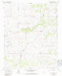
1963 Map of Orphan Annie Rock
USGS Topo · Published 1986About this map
Orphan Annie Rock stands as a prominent landmark in this high-desert portion of McKinley County, where the drainage systems of the American West split. The Continental Divide winds through the center of the sheet, dictating the flow of seasonal water into features like Sandoval Arroyo and Inditos Draw. This 1963 field-checked survey reveals a landscape primarily defined by its topographic relief and sparse ranching infrastructure.
Find a feature on this map
8 named features on this map. Tap any name to fly to it.
Don’t see what you’re looking for? This feature index may not catch every label — zoom into the map to look around manually.
Map Details
Editions of this 1963 Orphan Annie Rock Map
2 editions found
Other maps of this area

1883 · Mt. Taylor
USGS Topo · 1:250,000

1886 · Mt. Taylor
USGS Topo · 1:250,000

1892 · Mt. Taylor
USGS Topo · 1:250,000

1899 · Mt. Taylor
USGS Topo · 1:250,000

1958 · Albuquerque
USGS Topo · 1:250,000

1961 · Piedra De La Aguila
USGS Topo · 1:24,000

1961 · Whitehorse
USGS Topo · 1:24,000

1961 · Hospah
USGS Topo · 1:24,000

1962 · Albuquerque
USGS Topo · 1:250,000
1963 · Laguna Castillo
USGS Topo · 1:24,000