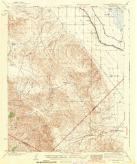
1943 Map of Ortigalita Peak
USGS Topo · Published 1943About this map
Ortigalita Peak anchors the rugged interior of the Diablo Range in this 1943 survey, marking a landscape where the arid ridges of the Panoche Hills meet the fertile western edge of the San Joaquin Valley. This era shows a transition from high-country ranching to valley-floor water management, evidenced by the intricate system of the San Joaquin and Kings River Canal and the Kings River Canal cutting across the eastern flats.
Find a feature on this map
36 named features on this map. Tap any name to fly to it.
Don’t see what you’re looking for? This feature index may not catch every label — zoom into the map to look around manually.
Map Details
Editions of this 1943 Ortigalita Peak Map
2 editions found

Other maps of this area

1913 · Panoche
USGS Topo · 1:125,000

1916 · Delta Ranch
USGS Topo · 1:24,000

1919 · San Benito
USGS Topo · 1:62,500

1920 · Pacheco Pass
USGS Topo · 1:62,500

1920 · Carrisalito Spring
USGS Topo · 1:31,680

1921 · Volta
USGS Topo · 1:31,680

1921 · Los Banos
USGS Topo · 1:31,680

1921 · Laguna Seca Ranch
USGS Topo · 1:31,680

1921 · Tierra Loma School
USGS Topo · 1:31,680

1922 · Charleston School
USGS Topo · 1:31,680