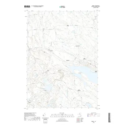
2019 Map of Orwell
USGS Topo · Published 2019About this map
Salmon River drainage systems define the landscape of eastern Oswego County, where water resources transition from natural features to engineered reservoirs. The expansive Salmon River Reservoir and Lower Reservoir dominate the central topography, supporting a power and recreation economy anchored by settlements like Altmar and Stillwater. Local history is preserved in the smaller hamlets and rural crossroads such as Orwell, Pekin, and Beecherville, which are connected by a network of county routes and family-named roads like Vorea Rd and Carpenter Rd. The presence of Chateaugay Cem and Pekin Cem provides tangible points of interest for genealogists tracing the early families of the Tug Hill region. Notable natural landmarks, including the Salmon River Falls and the swampy reaches of Tamarack Swamp, illustrate the varied hydrology of the area before the waters descend toward the Great Lakes basin.
Find a feature on this map
80 named features on this map. Tap any name to fly to it.
Don’t see what you’re looking for? This feature index may not catch every label — zoom into the map to look around manually.
Map Details
Editions of this 2019 Orwell Map
This is the sole edition of this map. No revisions or reprints were ever made.
Other maps of this area

1895 · Pulaski
USGS Topo · 1:62,500

1903 · Orwell
USGS Topo · 1:62,500

1905 · Orwell
USGS Topo · 1:62,500

1905 · Mexico
USGS Topo · 1:62,500

1906 · Kasoag
USGS Topo · 1:62,500

1942 · Sandy Creek
USGS Topo · 1:24,000

1942 · Redfield
USGS Topo · 1:24,000
1943 · Boylston
USGS Topo · 1:31,680

1943 · Redfield
USGS Topo · 1:31,680

1943 · Westdale
USGS Topo · 1:31,680