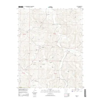
2014 Map of Osage
USGS Topo · Published 2014About this map
Osage and Conner anchor this portion of Carroll County, where the Ozark landscape is defined by the winding course of Osage Creek and its many tributaries like Piney Cr and Kenner Creek. The area is characterized by a high density of family cemeteries including Fancher Cem, York Cem, and McGehee Cem, suggesting a long-established rural population deeply rooted in the local valleys and ridges. Steep terrain features such as Black Mtn, Usrey Mtn, and Dewees Mtn divide the drainage basins, creating isolated pockets like Miller Hollow and Sally Hollow. Transportation follows these natural contours, with Ar 103 HWY S and Us-412 serving as the primary arteries connecting the small settlements of Gobbler, Rudd, and Dryfork. The map captures a portrait of a mountain community where agricultural land in the hollows meets the timbered slopes of the Arkansas highlands.
Find a feature on this map
96 named features on this map. Tap any name to fly to it.
Don’t see what you’re looking for? This feature index may not catch every label — zoom into the map to look around manually.
Map Details
Editions of this 2014 Osage Map
This is the sole edition of this map. No revisions or reprints were ever made.
Other maps of this area

1900 · Eureka Springs
USGS Topo · 1:125,000

1901 · Eureka Springs
USGS Topo · 1:125,000

1904 · Harrison
USGS Topo · 1:125,000

1905 · Harrison
USGS Topo · 1:125,000

1945 · Harrison
USGS Topo · 1:250,000

1949 · Harrison
USGS Topo · 1:250,000

1954 · Harrison
USGS Topo · 1:250,000

1958 · Harrison
USGS Topo · 1:250,000

1964 · Harrison
USGS Topo · 1:250,000
1967 · Ponca
USGS Topo · 1:24,000