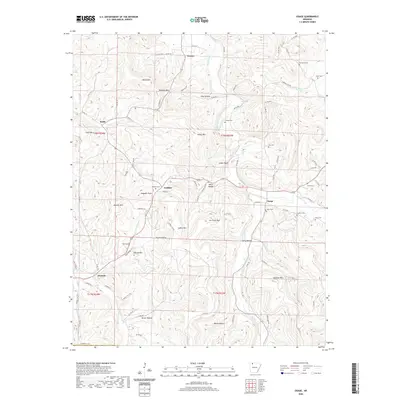
2020 Map of Osage
USGS Topo · Published 2020About this map
Osage Creek and its many tributaries, including Kenner Creek and Piney Cr, carve through this section of the Ozarks, defining the settlement patterns of Carroll Co. The small community of Osage sits at the convergence of several mountain roads near the Sisco Cem and Farcher Cem, illustrating the importance of water access in this elevated landscape. High points like Jim Fultz Mtn, Usrey Mtn, and Dewees Mtn overlook narrow valleys where family names are preserved through landmarks and resting places. Genealogists can trace local lineages at Mc Gehee Cem near Conner or York Cem further south. The map reveals a network of county roads connecting small outposts such as Rudd, Gobbler, and Dryfork, showing how the modern road system still follows the natural contours of the hills and hollows like Sally Hollow and Miller Hollow.
Find a feature on this map
88 named features on this map. Tap any name to fly to it.
Don’t see what you’re looking for? This feature index may not catch every label — zoom into the map to look around manually.
Map Details
Editions of this 2020 Osage Map
This is the sole edition of this map. No revisions or reprints were ever made.
Other maps of this area

1900 · Eureka Springs
USGS Topo · 1:125,000

1901 · Eureka Springs
USGS Topo · 1:125,000

1904 · Harrison
USGS Topo · 1:125,000

1905 · Harrison
USGS Topo · 1:125,000

1945 · Harrison
USGS Topo · 1:250,000

1949 · Harrison
USGS Topo · 1:250,000

1954 · Harrison
USGS Topo · 1:250,000

1958 · Harrison
USGS Topo · 1:250,000

1964 · Harrison
USGS Topo · 1:250,000
1967 · Ponca
USGS Topo · 1:24,000