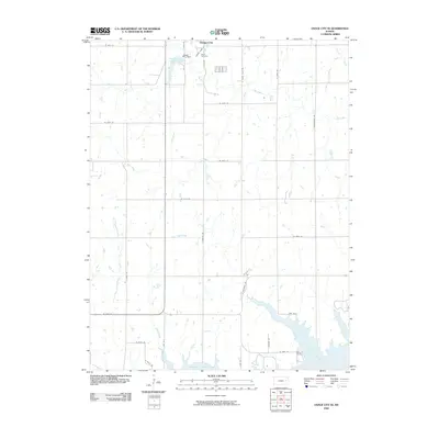
2009 Map of Osage City SE
USGS Topo · Published 2009About this map
The southern outskirts of Osage City transition into the rolling prairie landscape of Osage County in this 2009 survey. The northern edge of the map features the Osage City Reservoir and the Osage City Dam, essential infrastructure for the nearby settlement. To the south, the massive expanse of the Melvern Reservoir dominates the terrain, with recreation-oriented roads like Lakeview Dr and Lake Rd 8 skirting its northern arms.
Find a feature on this map
35 named features on this map. Tap any name to fly to it.
Don’t see what you’re looking for? This feature index may not catch every label — zoom into the map to look around manually.
Map Details
Editions of this 2009 Osage City SE Map
This is the sole edition of this map. No revisions or reprints were ever made.
Other maps of this area

1885 · Burlington
USGS Topo · 1:125,000

1889 · Burlingame
USGS Topo · 1:125,000

1894 · Burlingame
USGS Topo · 1:125,000

1894 · Burlington
USGS Topo · 1:125,000

1947 · Lawrence
USGS Topo · 1:250,000

1950 · Lawrence
USGS Topo · 1:250,000

1956 · Lawrence
USGS Topo · 1:250,000

1957 · Lebo
USGS Topo · 1:24,000

1957 · Waverly NW
USGS Topo · 1:24,000
1957 · Lebo NW
USGS Topo · 1:24,000