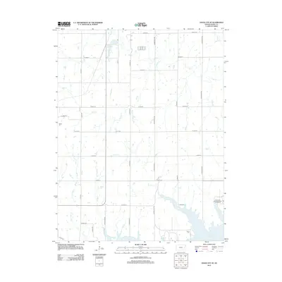
2012 Map of Osage City SE
USGS Topo · Published 2012About this map
Melvern Lake dominates the southern reaches of this landscape, its expansive shoreline shaping the local topography where Turkey Creek and other small tributaries feed into its northern arms. The terrain is defined by a grid of rural routes like S Indian Hills Rd and S Wanamaker Rd, which connect scattered homesteads and agricultural plots. In the northern section, the Osage City Reservoir and Salt Creek provide essential water resources for the area. This 2012 survey captures a quiet, rural Kansas environment where historic burial grounds such as Alpine Cemetery and Barclay Cemetery anchor the local genealogy. Recreational use of the reservoir system is evident at the Eisenhower State Park Cowboy Campground, reflecting the area's modern role as a destination for outdoor activity alongside its traditional farming roots.
Find a feature on this map
31 named features on this map. Tap any name to fly to it.
Don’t see what you’re looking for? This feature index may not catch every label — zoom into the map to look around manually.
Map Details
Editions of this 2012 Osage City SE Map
This is the sole edition of this map. No revisions or reprints were ever made.
Other maps of this area

1885 · Burlington
USGS Topo · 1:125,000

1889 · Burlingame
USGS Topo · 1:125,000

1894 · Burlingame
USGS Topo · 1:125,000

1894 · Burlington
USGS Topo · 1:125,000

1947 · Lawrence
USGS Topo · 1:250,000

1950 · Lawrence
USGS Topo · 1:250,000

1956 · Lawrence
USGS Topo · 1:250,000

1957 · Lebo
USGS Topo · 1:24,000

1957 · Waverly NW
USGS Topo · 1:24,000
1957 · Lebo NW
USGS Topo · 1:24,000