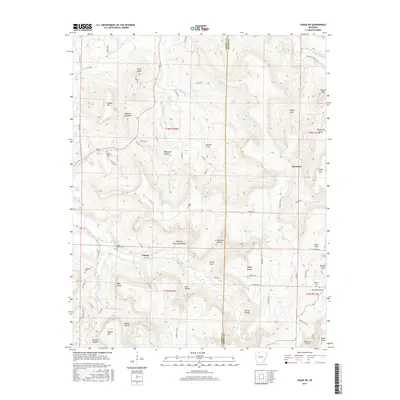
2017 Map of Osage NE
USGS Topo · Published 2017About this map
Delmar and the surrounding highlands of the Ozark Plateau define this landscape where the Osage Creek watershed has carved a complex network of coves and hollows. The settlement pattern is largely dictated by these drainage systems, with family and community landmarks such as the Shady Grove Cem and Dog Branch Cem situated near the valley floors. High points like Pilot Knob, Holden Mtn, and Needle Eye Mtn provide prominent vertical relief above the deep recesses of Winding Staircase Hollow and Whooping Hollow. To the east, the community of Red Bank sits near the headwaters of Long Cr. This terrain is characterized by numerous small springs and named drainages like Dishroom Cr and Big Spring, which sustained the dispersed rural homesteads and early churchyards found throughout the region.
Find a feature on this map
80 named features on this map. Tap any name to fly to it.
Don’t see what you’re looking for? This feature index may not catch every label — zoom into the map to look around manually.
Map Details
Editions of this 2017 Osage NE Map
This is the sole edition of this map. No revisions or reprints were ever made.
Other maps of this area

1904 · Harrison
USGS Topo · 1:125,000

1905 · Harrison
USGS Topo · 1:125,000

1945 · Harrison
USGS Topo · 1:250,000

1949 · Harrison
USGS Topo · 1:250,000

1954 · Harrison
USGS Topo · 1:250,000

1958 · Harrison
USGS Topo · 1:250,000

1964 · Harrison
USGS Topo · 1:250,000
1967 · Gaither
USGS Topo · 1:24,000
1967 · Jasper
USGS Topo · 1:24,000
1967 · Ponca
USGS Topo · 1:24,000