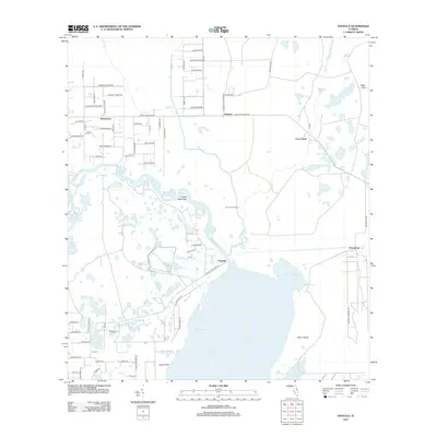
2012 Map of Osceola
USGS Topo · Published 2012About this map
Lake Harney and the meandering Saint Johns River dominate this landscape, where the shifting wetlands of the St. Johns valley meet the growing road networks of Volusia County. The map documents the intricate hydrology of the region, from the wide waters of Mullet Lake to narrow channels like Cow House Slough and the Forks of the Creek. Settlement is concentrated in pockets such as Osceola and the established grids of Kalamazoo, while rural crossroads like Farmton and Pennichaw remain distinct landmarks amidst the hammocks and sloughs. Named features like Stone Island and Clark Hammock reveal the importance of dry ground in this river-driven environment, providing insight into early Florida land use and the development of local roads like Osteen Maytown Rd which bridge the gaps between these disparate settlements and the winding river system.
Find a feature on this map
75 named features on this map. Tap any name to fly to it.
Don’t see what you’re looking for? This feature index may not catch every label — zoom into the map to look around manually.
Map Details
Editions of this 2012 Osceola Map
This is the sole edition of this map. No revisions or reprints were ever made.
Other maps of this area

1949 · Osceola
USGS Topo · 1:24,000

1950 · Maytown
USGS Topo · 1:24,000

1950 · Edgewater
USGS Topo · 1:24,000

1950 · Aurantia
USGS Topo · 1:24,000

1953 · Geneva
USGS Topo · 1:24,000

1955 · Orlando
USGS Topo · 1:250,000

1956 · Oviedo
USGS Topo · 1:24,000

1957 · Orlando
USGS Topo · 1:250,000

1958 · Orlando
USGS Topo · 1:250,000

1962 · Orlando
USGS Topo · 1:250,000