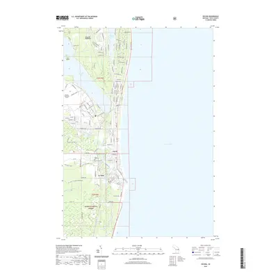
2019 Map of Oscoda
USGS Topo · Published 2019About this map
The Au Sable River and the shoreline of Lake Huron anchor this coastal landscape, where the communities of Oscoda and Au Sable sit at the river's mouth. This 2019 survey captures the developed corridor along Huron Rd, illustrating a network of modern residential streets like Chippewa Ave and Gaston Way that have filled the space between Cedar Lake and the big water. Further inland, the vast reaches of the Huron National Forest dominate the southern half of the map, providing a stark contrast to the infrastructure of the Oscoda-Wurtsmith Airport to the northwest. Genealogists will find the locations of Sacred Heart Cem, Pinecrest Cem, and the Au Sable Township Cem clearly marked near the river. Water features such as Van Etten Lake, Duell Lake, and Loud Island define the local geography, while the Old Au Sable River traces its winding path through the forest wetlands.
Find a feature on this map
115 named features on this map. Tap any name to fly to it.
Don’t see what you’re looking for? This feature index may not catch every label — zoom into the map to look around manually.
Map Details
Editions of this 2019 Oscoda Map
This is the sole edition of this map. No revisions or reprints were ever made.
Other maps of this area
1954 · Tawas City
USGS Topo · 1:250,000
1958 · Tawas City
USGS Topo · 1:250,000
1959 · East Tawas
USGS Topo · 1:62,500
1959 · Harrisville
USGS Topo · 1:62,500
1983 · Hubbard Lake
USGS Topo · 1:100,000
1984 · Tawas City
USGS Topo · 1:100,000
1989 · Mikado
USGS Topo · 1:24,000
1989 · Greenbush
USGS Topo · 1:24,000
1989 · Foote Site Village
USGS Topo · 1:24,000
1989 · East Tawas
USGS Topo · 1:24,000