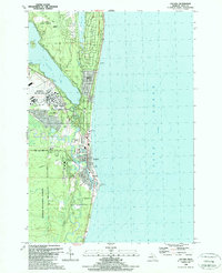
1989 Map of Oscoda
USGS Topo · Published 1989About this map
Wurtsmith Air Force Base dominates the northern landscape of this Iosco County shoreline as it appeared in the late 1980s. The military installation, complete with its runways and dedicated boundary lines, sits just west of Van Etten Lake and north of the central settlement at Oscoda. Along the coast, the community of Au Sable marks the mouth of the Au Sable River, a critical waterway for the region's historical development. The map details a transition from the structured street grids of the coastal towns to the protected woodlands of the Huron National Forest and Au Sable State Forest. Evidence of older industry and transportation remains visible through labels like the Old RR Grade and Skeel Spur, while local civic life is anchored by landmarks such as Sacred Heart Ch, Trinity Ch, and the Cedar Lake Sch.
Find a feature on this map
37 named features on this map. Tap any name to fly to it.
Don’t see what you’re looking for? This feature index may not catch every label — zoom into the map to look around manually.
Map Details
Editions of this 1989 Oscoda Map
This is the sole edition of this map. No revisions or reprints were ever made.
Other maps of this area

1954 · Tawas City
USGS Topo · 1:250,000

1958 · Tawas City
USGS Topo · 1:250,000

1959 · East Tawas
USGS Topo · 1:62,500

1959 · Harrisville
USGS Topo · 1:62,500

1983 · Hubbard Lake
USGS Topo · 1:100,000

1984 · Tawas City
USGS Topo · 1:100,000

1989 · Mikado
USGS Topo · 1:24,000
1989 · Greenbush
USGS Topo · 1:24,000
1989 · Foote Site Village
USGS Topo · 1:24,000
1989 · East Tawas
USGS Topo · 1:24,000