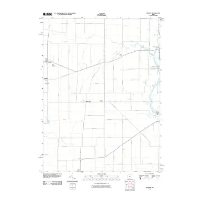
2010 Map of Osgood
USGS Topo · Published 2010About this map
Fort Loramie and the surrounding agricultural landscape of the Darke-Shelby county line are meticulously documented in this 2010 study. The map serves as a detailed record of small-town Ohio, highlighting the proximity of Osgood, Yorkshire, and Willowdell. A high density of rural burial sites, including Saint Martins Cemetery, Mendenhall Cemetery, and Walkup Cemetery, provides a wealth of data for genealogists tracking local families. The drainage patterns of the region are defined by Mile Creek and Loramie Creek, which flows into the man-made Barhorst Lake at the eastern edge. Local infrastructure is anchored by the Osgood Post Office and a grid of family-named roads like Buening Rd and Kremer Rd that trace the historical divisions of the farmland.
Find a feature on this map
66 named features on this map. Tap any name to fly to it.
Don’t see what you’re looking for? This feature index may not catch every label — zoom into the map to look around manually.
Map Details
Editions of this 2010 Osgood Map
This is the sole edition of this map. No revisions or reprints were ever made.
Other maps of this area

1908 · St. Henry
USGS Topo · 1:62,500

1909 · Loramie
USGS Topo · 1:62,500

1911 · Loramie
USGS Topo · 1:62,500

1911 · Covington
USGS Topo · 1:62,500

1944 · Covington
USGS Topo · 1:62,500

1944 · Loramie
USGS Topo · 1:62,500

1953 · Muncie
USGS Topo · 1:250,000

1956 · Muncie
USGS Topo · 1:250,000

1961 · Dawn
USGS Topo · 1:24,000
1961 · Piqua West
USGS Topo · 1:24,000