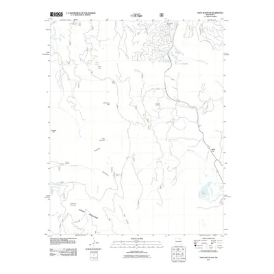
2011 Map of Osha Mountain
USGS Topo · Published 2011About this map
Osha Mountain and the Rincon Mountains dominate this high-altitude landscape in the Sangre de Cristo range. The 2011 survey details the suburban expansion of Angle Fire and Monte Verde Unit One into the canyon and meadow systems of the southern Moreno Valley. In contrast to the developed north, the southern portion of the sheet remains largely defined by its natural drainage systems, including the Mora River, Coyote Creek, and the mountain waters of Black Lake. Local history is anchored by the Black Lake Cemetery and the industrial footprint of the Torres Pit. Movement through this varied terrain is traced along several high passes like Osha Pass and Quintana Pass, while the lower parklands of Little Garcia Park and Jarocita Park illustrate the traditional mountain meadows used by generations of New Mexican settlers.
Find a feature on this map
49 named features on this map. Tap any name to fly to it.
Don’t see what you’re looking for? This feature index may not catch every label — zoom into the map to look around manually.
Map Details
Editions of this 2011 Osha Mountain Map
This is the sole edition of this map. No revisions or reprints were ever made.
Other maps of this area

1954 · Raton
USGS Topo · 1:250,000

1956 · Tooth Of Time
USGS Topo · 1:62,500

1958 · Raton
USGS Topo · 1:250,000

1965 · Osha Mountain
USGS Topo · 1:24,000

1965 · Chacon
USGS Topo · 1:24,000

1965 · Palo Flechado Pass
USGS Topo · 1:24,000

1965 · Pueblo Peak
USGS Topo · 1:24,000

1965 · Shady Brook
USGS Topo · 1:24,000
1965 · Cerro Vista
USGS Topo · 1:24,000

1966 · Guadalupita
USGS Topo · 1:24,000