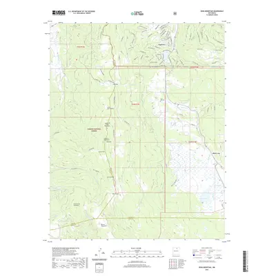
2020 Map of Osha Mountain
USGS Topo · Published 2020About this map
The village of Angel Fire sits in the northern highlands of the Sangre de Cristo Mountains, where the local landscape is defined by the high-altitude transition from the Santa Fe Mountains to the valley floor. This 2020 survey documents a modern resort layout, with streets like Cimarron Trl and Taos Dr carved into the slopes northwest of Osha Mtn. To the south, the settlement of Black Lake and the nearby Black Lake Cem sit within the Carson National Forest, marking an area with deeper roots than the mid-century resort developments to the north. The geography is characterized by intricate drainage systems, including the headwaters of the Mora River and Coyote Cr, alongside natural basins like Black Lakes. This sheet captures the intersection of three counties—Taos, Colfax, and Mora—illustrating how the high peaks and passes like Osha Pass have dictated transit and land use in this part of New Mexico.
Find a feature on this map
89 named features on this map. Tap any name to fly to it.
Don’t see what you’re looking for? This feature index may not catch every label — zoom into the map to look around manually.
Map Details
Editions of this 2020 Osha Mountain Map
This is the sole edition of this map. No revisions or reprints were ever made.
Other maps of this area

1954 · Raton
USGS Topo · 1:250,000

1956 · Tooth Of Time
USGS Topo · 1:62,500

1958 · Raton
USGS Topo · 1:250,000

1965 · Osha Mountain
USGS Topo · 1:24,000

1965 · Chacon
USGS Topo · 1:24,000

1965 · Palo Flechado Pass
USGS Topo · 1:24,000

1965 · Pueblo Peak
USGS Topo · 1:24,000

1965 · Shady Brook
USGS Topo · 1:24,000
1965 · Cerro Vista
USGS Topo · 1:24,000

1966 · Guadalupita
USGS Topo · 1:24,000