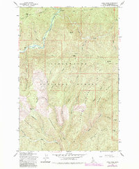
1965 Map of Osier Ridge
USGS Topo · Published 1984About this map
Moose City marks a significant historical waypoint within the Clearwater National Forest, where the complex drainage systems of Moose Creek and Independence Creek converge below Independence Ridge. This 1965 survey, updated through the early 1980s, reveals a wilderness infrastructure defined by a network of Pack Trails and Jeep Trails rather than modern highways. The northern section is dominated by the North Fork Clearwater River, which winds past The Cedars and the Cedars Mile Picnic Area. The landscape is characterized by high-elevation ridges such as Osier Ridge, capped by the Osier Ridge Lookout Tower, and Laundry Ridge, which separate deep canyons like Deception Gulch and Sailor Gulch. These terrain patterns illustrate the region's historical reliance on seasonal monitoring and trail-based transport through the Idaho interior.
Find a feature on this map
41 named features on this map. Tap any name to fly to it.
Don’t see what you’re looking for? This feature index may not catch every label — zoom into the map to look around manually.
Map Details
Editions of this 1965 Osier Ridge Map
2 editions found
Other maps of this area

1911 · Lolo
USGS Topo · 1:250,000

1913 · Lolo
USGS Topo · 1:250,000

1956 · Hamilton
USGS Topo · 1:250,000

1959 · Hamilton
USGS Topo · 1:250,000

1960 · Hamilton
USGS Topo · 1:250,000

1960 · Straight Peak
USGS Topo · 1:62,500

1964 · Hamilton
USGS Topo · 1:250,000
1965 · Hoodoo Pass
USGS Topo · 1:24,000

1965 · Osier Ridge
USGS Topo · 1:24,000
1965 · Moose Mtn
USGS Topo · 1:24,000