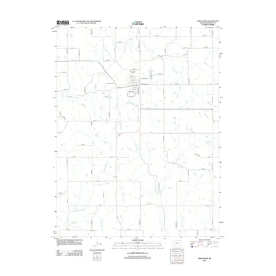
2012 Map of Oskaloosa
USGS Topo · Published 2012About this map
Oskaloosa serves as a central hub for this portion of Jefferson County, defined by a grid of rural roads and a complex network of prairie streams. The town itself is structured around a traditional street plan featuring Atchison St, Cherokee St, and E Jefferson St, with a Po located near the town center. Local history is anchored at sites like Pleasant View Cem and Buster Cem, providing valuable points of reference for genealogists studying the region's long-established families.
Find a feature on this map
58 named features on this map. Tap any name to fly to it.
Don’t see what you’re looking for? This feature index may not catch every label — zoom into the map to look around manually.
Map Details
Editions of this 2012 Oskaloosa Map
This is the sole edition of this map. No revisions or reprints were ever made.
Other maps of this area

1886 · Oskaloosa
USGS Topo · 1:125,000

1888 · Oskaloosa
USGS Topo · 1:125,000

1894 · Oskaloosa
USGS Topo · 1:125,000

1949 · Williamstown
USGS Topo · 1:24,000

1949 · Perry
USGS Topo · 1:24,000

1950 · Perry
USGS Topo · 1:24,000

1950 · Kansas City
USGS Topo · 1:250,000

1950 · Williamstown
USGS Topo · 1:24,000
1950 · Midland
USGS Topo · 1:24,000

1950 · Mc Louth
USGS Topo · 1:24,000