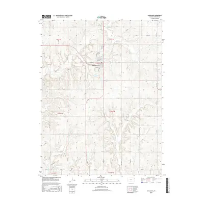
2015 Map of Oskaloosa
USGS Topo · Published 2015About this map
Oskaloosa serves as the central hub of this Kansas landscape, where a dense grid of streets like Washington St and Monroe St meets the rural section lines of Jefferson County. The town is flanked by rolling drainage patterns, with Burr Oak Br and Slough Cr winding through the northern reaches. To the south, the topography is defined by the symmetrical drainages of W Stone House Cr and E Stone House Cr, reflecting the region's agricultural character. Genealogists will find interest in the documented locations of Pleasant View Cem north of the town center and Buster Cem near the southern boundary. The map illustrates a transition from the structured township system of t9s r19e to the natural riparian corridors of Buck Cr and its tributaries, showing the long-standing relationship between settlement and the local watershed.
Find a feature on this map
69 named features on this map. Tap any name to fly to it.
Don’t see what you’re looking for? This feature index may not catch every label — zoom into the map to look around manually.
Map Details
Editions of this 2015 Oskaloosa Map
This is the sole edition of this map. No revisions or reprints were ever made.
Other maps of this area

1886 · Oskaloosa
USGS Topo · 1:125,000

1888 · Oskaloosa
USGS Topo · 1:125,000

1894 · Oskaloosa
USGS Topo · 1:125,000

1949 · Williamstown
USGS Topo · 1:24,000

1949 · Perry
USGS Topo · 1:24,000

1950 · Perry
USGS Topo · 1:24,000

1950 · Kansas City
USGS Topo · 1:250,000

1950 · Williamstown
USGS Topo · 1:24,000
1950 · Midland
USGS Topo · 1:24,000

1950 · Mc Louth
USGS Topo · 1:24,000