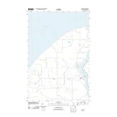
2011 Map of Oskar
USGS Topo · Published 2011About this map
The Keweenaw Peninsula's western shore meets Lake Superior in this study of the rural landscape north of Redridge. Small settlements like Oskar and Liminga anchor a network of country roads, including Houghton Canal Rd and N Superior Rd, that trace the high ground above Portage Lake. The geography here is defined by short, fast-running waterways such as Schlot Creek, Keranen Creek, and the Salmon Trout River, which drain the interior toward the Great Lake. Local genealogy is supported by the inclusion of the Oskar Cemetery and Redridge Cemetery, while place names like Little America and Schmidt Corner reflect the localized cultural history of this copper country periphery. Notable coastal landmarks include Mill Point and High Point, alongside the sheltered waters around Harrington Island, providing a clear record of the shoreline's physical profile.
Find a feature on this map
44 named features on this map. Tap any name to fly to it.
Don’t see what you’re looking for? This feature index may not catch every label — zoom into the map to look around manually.
Map Details
Editions of this 2011 Oskar Map
This is the sole edition of this map. No revisions or reprints were ever made.
Other maps of this area

1915 · Houghton
USGS Topo · 1:62,500

1946 · Hancock
USGS Topo · 1:24,000

1946 · Chassell
USGS Topo · 1:24,000

1946 · South Range
USGS Topo · 1:24,000

1946 · Muggun Creek
USGS Topo · 1:24,000

1948 · South Range
USGS Topo · 1:24,000
1948 · Muggun Creek
USGS Topo · 1:24,000

1948 · Hancock
USGS Topo · 1:24,000

1948 · Chassell
USGS Topo · 1:24,000

1954 · Graveraet River
USGS Topo · 1:24,000