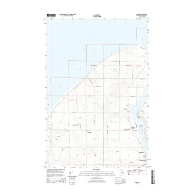
2014 Map of Oskar
USGS Topo · Published 2014About this map
The northern reaches of the Keweenaw Peninsula meet Lake Superior in this study of the coastal landscape northwest of Houghton. Small, rural settlements like Oskar and Liminga are connected by a network of local roads such as Liminga Rd and N Superior Rd, reflecting the area's history of agricultural and homesteading activity. Along the eastern edge, the Keweenaw Waterway serves as a critical maritime corridor, separating the mainland from Harrington Island and providing access to the industrial centers of Hancock and the county seat. Inland, the terrain is shaped by numerous small watercourses including Schlot Cr and Keranen Cr, while local landmarks like High Point and Tear Lake provide distinctive points of reference. The presence of the Oskar Cem and Redridge Cem offers vital data points for genealogists tracing family roots in this corner of the Copper Country.
Find a feature on this map
58 named features on this map. Tap any name to fly to it.
Don’t see what you’re looking for? This feature index may not catch every label — zoom into the map to look around manually.
Map Details
Editions of this 2014 Oskar Map
This is the sole edition of this map. No revisions or reprints were ever made.
Other maps of this area

1915 · Houghton
USGS Topo · 1:62,500

1946 · Hancock
USGS Topo · 1:24,000

1946 · Chassell
USGS Topo · 1:24,000

1946 · South Range
USGS Topo · 1:24,000

1946 · Muggun Creek
USGS Topo · 1:24,000

1948 · South Range
USGS Topo · 1:24,000
1948 · Muggun Creek
USGS Topo · 1:24,000

1948 · Hancock
USGS Topo · 1:24,000

1948 · Chassell
USGS Topo · 1:24,000

1954 · Graveraet River
USGS Topo · 1:24,000