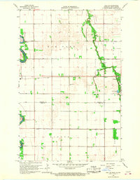
1966 Map of Oslo NE
USGS Topo · Published 1968About this map
The Red River corridor defines this landscape at the border of Minnesota and North Dakota, where the winding Snake River joins the main valley near Alvarado. The 1966 survey illustrates a strictly organized agricultural grid across the townships of Oak Park, Vega, Higdem, and Sandsville. This region is characterized by a sophisticated drainage network of man-made waterways, including Judicial Ditch No 1 and County Ditch No 21, essential for managing the flat river bottom lands. Transportation is centered on the Soo Line railroad, which parallels the highway through Oslo. Local heritage is anchored by scattered rural institutions like the Mesopotamia Cem and Elim Ch, which alongside the Swedish Cem, indicate the specific settlement patterns of the families who farmed these Marshall and Polk County lands.
Find a feature on this map
27 named features on this map. Tap any name to fly to it.
Don’t see what you’re looking for? This feature index may not catch every label — zoom into the map to look around manually.
Map Details
Editions of this 1966 Oslo NE Map
This is the sole edition of this map. No revisions or reprints were ever made.
Other maps of this area

1918 · Acton
USGS Topo · 1:62,500

1918 · Argyle
USGS Topo · 1:62,500

1918 · Warren
USGS Topo · 1:62,500

1952 · Thief River Falls
USGS Topo · 1:250,000

1954 · Stephen
USGS Topo · 1:62,500

1955 · Warren
USGS Topo · 1:62,500

1956 · Thief River Falls
USGS Topo · 1:250,000

1957 · Thief River Falls
USGS Topo · 1:250,000
1966 · Big Woods
USGS Topo · 1:24,000
1966 · Oslo
USGS Topo · 1:24,000