1984 Map of Osseo
USGS Topo · Published 1984About this map
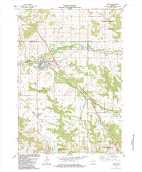
Osseo serves as the focal point of this mid-1980s survey, situated where the North Fork Buffalo River and South Fork Buffalo River converge. The town's layout includes established landmarks such as Stoddard Park Country Club and Martha Lake, reflecting a community integrated with its riverine environment. Beyond the town limits, the landscape is defined by agricultural lands and significant conservation tracts, including the State Fork Fishery Area and Tollefson Marsh State Wildlife Area. This era shows a well-developed rural infrastructure with roads like Haskins Road and Ryder Road connecting dispersed farmsteads and rural centers. Local history is preserved in the location of the King Valley Ch and South Valley Cem, while the industrial presence is marked by various Gravel Pits and a Shale Pit scattered throughout the surrounding townships.
Find a feature on this map
37 named features on this map. Tap any name to fly to it.
Don’t see what you’re looking for? This feature index may not catch every label — zoom into the map to look around manually.
Map Details
Editions of this 1984 Osseo Map
This is the sole edition of this map. No revisions or reprints were ever made.
Other maps of this area

1926 · Whitehall
USGS Topo · 1:62,500

1927 · Blair
USGS Topo · 1:62,500

1927 · Strum
USGS Topo · 1:62,500

1929 · Whitehall
USGS Topo · 1:62,500

1930 · Strum
USGS Topo · 1:62,500

1935 · Osseo
USGS Topo · 1:48,000

1940 · Osseo
USGS Topo · 1:62,500

1953 · Eau Claire
USGS Topo · 1:250,000

1958 · Eau Claire
USGS Topo · 1:250,000

1964 · Eau Claire
USGS Topo · 1:250,000