
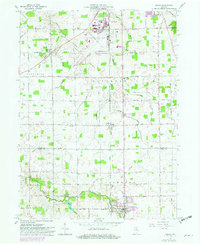
1962 Map of Ossian
USGS Topo · Published 1963About this map
Ossian serves as the primary hub in the southern portion of this early 1960s landscape, while Nine Mile and Yoder anchor smaller rural concentrations to the north. The presence of the Indiana Air National Guard and Fort Wayne Municipal Airport (Baer Field) indicates the significant aviation infrastructure established on the outskirts of the region. Local genealogy is well-represented through numerous burial grounds and places of worship, including Fogwell Cem, Brenton Chapel Cem, and Bethel Ch. The terrain is defined by a dense network of man-made drainage, such as Harber Ditch and Thiele Ditch, which support the agricultural tracts between Eightmile Creek and Robinson Creek. Educational life is captured through scattered rural institutions like St Aloysius Sch and the Twp Sch, reflecting the community structure of Allen and Wells Counties during this era.
Find a feature on this map
50 named features on this map. Tap any name to fly to it.
Don’t see what you’re looking for? This feature index may not catch every label — zoom into the map to look around manually.
Map Details
Editions of this 1962 Ossian Map
2 editions found
Other maps of this area

1953 · Fort Wayne
USGS Topo · 1:250,000

1953 · Muncie
USGS Topo · 1:250,000

1955 · Markle
USGS Topo · 1:24,000

1956 · Muncie
USGS Topo · 1:250,000

1956 · Fort Wayne
USGS Topo · 1:250,000

1956 · Fort Wayne West
USGS Topo · 1:24,000

1956 · Fort Wayne East
USGS Topo · 1:24,000

1961 · Arcola
USGS Topo · 1:24,000
1961 · Zanesville
USGS Topo · 1:24,000

1962 · Poe
USGS Topo · 1:24,000