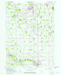
1962 Map of Ossian
USGS Topo · Published 1982About this map
Ossian serves as the primary hub in this early 1960s survey of the Wells and Allen County line, reflecting a landscape defined by organized drainage and rural infrastructure. The Norfolk and Western railroad corridor anchors the eastern half of the map, passing through the town and northward toward the Fort Wayne Municipal Airport (Baer Field). This northern area is notably busy, featuring the Indiana Air National Guard facilities and an Airway Beacon.
Find a feature on this map
54 named features on this map. Tap any name to fly to it.
Don’t see what you’re looking for? This feature index may not catch every label — zoom into the map to look around manually.
Map Details
Editions of this 1962 Ossian Map
2 editions found

Other maps of this area

1953 · Fort Wayne
USGS Topo · 1:250,000

1953 · Muncie
USGS Topo · 1:250,000

1955 · Markle
USGS Topo · 1:24,000

1956 · Muncie
USGS Topo · 1:250,000

1956 · Fort Wayne
USGS Topo · 1:250,000

1956 · Fort Wayne West
USGS Topo · 1:24,000

1956 · Fort Wayne East
USGS Topo · 1:24,000

1961 · Arcola
USGS Topo · 1:24,000
1961 · Zanesville
USGS Topo · 1:24,000

1962 · Poe
USGS Topo · 1:24,000