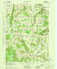
1944 Map of Ossian
USGS Topo · Published 1944About this map
The Ossian township region along the boundary of Livingston and Allegany Counties is captured here during the mid-1940s. The landscape is defined by the drainage systems of Sugar Creek and Bradner Creek, which cut through the high ground of East Hill and the steep terrain of Wildcat Gully. This era shows a network of rural routes including the historic Telegraph Road and Dansville Road, connecting the small settlements of Westview, Byersville, and the community of Ossian.
Find a feature on this map
18 named features on this map. Tap any name to fly to it.
Don’t see what you’re looking for? This feature index may not catch every label — zoom into the map to look around manually.
Map Details
Editions of this 1944 Ossian Map
This is the sole edition of this map. No revisions or reprints were ever made.
Other maps of this area

1902 · Wayland
USGS Topo · 1:62,500

1904 · Wayland
USGS Topo · 1:62,500

1905 · Nunda
USGS Topo · 1:62,500

1915 · Hornell
USGS Topo · 1:62,500

1916 · Canaseraga
USGS Topo · 1:62,500

1918 · Hornell
USGS Topo · 1:62,500

1940 · Canaseraga
USGS Topo · 1:62,500

1942 · Dansville
USGS Topo · 1:31,680

1942 · Conesus
USGS Topo · 1:31,680

1943 · Mount Morris
USGS Topo · 1:24,000