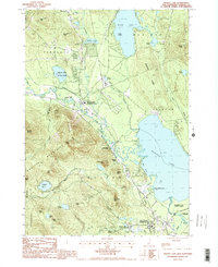
1987 Map of Ossipee Lake
USGS Topo · Published 1987About this map
Ossipee Lake and its surrounding river systems serve as the centerpiece of this Carroll County landscape, where the Bearcamp River, Chocorua River, and West Branch converge before entering the lake at Deer Cove. The settlement pattern in the late 1980s reveals a mix of recreational and village centers, including West Ossipee and Center Ossipee, both of which retain their historic rail-station designations despite the nearby abandoned rail line. Conservation and leisure are prominently featured through White Lake State Park, Ossipee Lake State Park, and Lord Pines State Forest. To the south and west, the terrain rises sharply into the Ossipee Mountains, featuring peaks like Mount Whittier and Raccoon Mountain, which define the southwestern boundary of the basin.
Find a feature on this map
54 named features on this map. Tap any name to fly to it.
Don’t see what you’re looking for? This feature index may not catch every label — zoom into the map to look around manually.
Map Details
Editions of this 1987 Ossipee Lake Map
This is the sole edition of this map. No revisions or reprints were ever made.
Other maps of this area

1909 · Winnepesaukee
USGS Topo · 1:62,500

1928 · Wolfeboro
USGS Topo · 1:62,500

1930 · Ossipee Lake
USGS Topo · 1:62,500

1931 · Mt. Chocorua
USGS Topo · 1:62,500

1949 · Portland
USGS Topo · 1:250,000

1956 · Winnipesaukee
USGS Topo · 1:62,500

1956 · Portland
USGS Topo · 1:250,000

1958 · Ossipee Lake
USGS Topo · 1:62,500

1958 · Wolfeboro
USGS Topo · 1:62,500

1958 · Mt. Chocorua
USGS Topo · 1:62,500