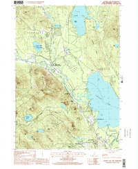
1998 Map of Ossipee Lake
USGS Topo · Published 2001About this map
Ossipee Lake and the Bearcamp River basin dominate this landscape at the intersection of several New Hampshire towns, including Madison, Tamworth, and Ossipee. The map documents the region's transition from its rail-oriented past to a recreation-based economy. Evidence of the former rail infrastructure is found at West Ossipee and Center Ossipee, where station names linger in the labels. Significant conservation and seasonal areas are prominent, such as White Lake State Park, Camp Weetamoe, and the Heath Pond Bog State Natural Area. The southern portion is defined by the Ossipee Mountains, including Mount Whittier and Grant Peak, which overlook the river valleys and the clustered settlements of Moultonville and Ossipee Valley.
Find a feature on this map
60 named features on this map. Tap any name to fly to it.
Don’t see what you’re looking for? This feature index may not catch every label — zoom into the map to look around manually.
Map Details
Editions of this 1998 Ossipee Lake Map
This is the sole edition of this map. No revisions or reprints were ever made.
Other maps of this area

1909 · Winnepesaukee
USGS Topo · 1:62,500

1928 · Wolfeboro
USGS Topo · 1:62,500

1930 · Ossipee Lake
USGS Topo · 1:62,500

1931 · Mt. Chocorua
USGS Topo · 1:62,500

1949 · Portland
USGS Topo · 1:250,000

1956 · Winnipesaukee
USGS Topo · 1:62,500

1956 · Portland
USGS Topo · 1:250,000

1958 · Ossipee Lake
USGS Topo · 1:62,500

1958 · Wolfeboro
USGS Topo · 1:62,500

1958 · Mt. Chocorua
USGS Topo · 1:62,500