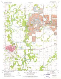
1974 Map of Oswego
USGS Topo · Published 1976About this map
Oswego serves as the focal point of this Labette County landscape, situated where the St Louis - San Francisco and Missouri - Kansas - Texas railroads intersect near the winding Neosho River. The mid-1970s terrain reveals a legacy of resource extraction, most notably the extensive Strip Pits State Wildlife Management Area where former coal mines have been reclaimed for public use. These pits, often filled with water and flanked by Lightning Creek and Wolf Creek, dominate the eastern half of the map across the Cherokee Co line.
Find a feature on this map
37 named features on this map. Tap any name to fly to it.
Don’t see what you’re looking for? This feature index may not catch every label — zoom into the map to look around manually.
Map Details
Editions of this 1974 Oswego Map
This is the sole edition of this map. No revisions or reprints were ever made.
Other maps of this area

1886 · Joplin
USGS Topo · 1:125,000

1886 · Parsons
USGS Topo · 1:125,000

1893 · Parsons
USGS Topo · 1:125,000

1894 · Joplin
USGS Topo · 1:125,000

1918 · Columbus
USGS Topo · 1:62,500

1943 · McCune
USGS Topo · 1:62,500

1943 · Cherokee
USGS Topo · 1:62,500

1944 · Oswego
USGS Topo · 1:62,500

1945 · Mc Cune
USGS Topo · 1:62,500

1945 · Cherokee
USGS Topo · 1:62,500