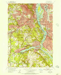
1954 Map of Oswego
USGS Topo · Published 1957About this map
Portland south into the Willamette River valley reveals a landscape of mid-century suburban expansion and established academic and recreational institutions. The terrain is defined by the Tualatin Mountains, where Council Crest and Marquam Hill overlook the city, while Mt Sylvania rises further south. This era shows the dense cluster of neighborhoods including Fulton, Hillsdale, and Multnomah, as well as the transition into Clackamas County toward the lakeside community of South Oswego.
Find a feature on this map
110 named features on this map. Tap any name to fly to it.
Don’t see what you’re looking for? This feature index may not catch every label — zoom into the map to look around manually.
Map Details
Editions of this 1954 Oswego Map
This is the sole edition of this map. No revisions or reprints were ever made.
Other maps of this area

1897 · Portland
USGS Topo · 1:62,500

1905 · Portland
USGS Topo · 1:62,500

1914 · Oregon City
USGS Topo · 1:62,500

1915 · Hillsboro
USGS Topo · 1:62,500

1916 · Tualatin
USGS Topo · 1:62,500

1918 · Hillsboro
USGS Topo · 1:62,500

1939 · Oregon City
USGS Topo · 1:62,500

1939 · Tualatin
USGS Topo · 1:62,500

1940 · Tualatin
USGS Topo · 1:62,500

1940 · Hillsboro
USGS Topo · 1:62,500