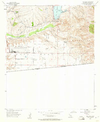
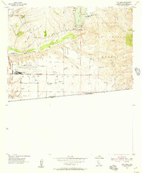
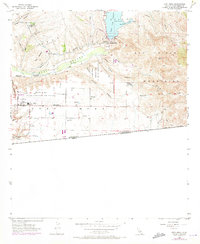
1955 Map of Otay Mesa
USGS Topo · Published 1961About this map
The international boundary between California and Mexico defines the southern reach of this mid-century survey, where the Otay Mesa plateau meets the San Ysidro Mountains. At the heart of the mesa sits the Brown Field Naval Auxiliary Air Station, a significant Cold War-era military footprint flanked by a Bombing Range. This area reveals a landscape in transition, where legacy agricultural operations like Otay Ranch, Bird Ranch, and Kuebler Ranch persist alongside federal infrastructure and the Alta School.
Find a feature on this map
37 named features on this map. Tap any name to fly to it.
Don’t see what you’re looking for? This feature index may not catch every label — zoom into the map to look around manually.
Map Details
Editions of this 1955 Otay Mesa Map
4 editions found
Historical Maps of San Diego Through Time
343 maps found

1893 Elcajon
San Diego County, CA

1901 Elcajon
San Diego County, CA

1901 San Luis Rey
San Diego County, CA

1903 Cuyamaca
San Diego County, CA

1903 La Jolla
San Diego County, CA

1930 La Jolla
San Diego County, CA

1931 Carrizo
San Diego County, CA

1931 Vallecito
San Diego County, CA

1939 Borrego
San Diego County, CA

1939 Palomar Mountain
San Diego County, CA

1939 Santa Ysabel
San Diego County, CA

1939 Warner Springs
San Diego County, CA

1941 Clark Lake
San Diego County, CA

1941 Margarita Peak
San Diego County, CA

1942 Agua Dulce
San Diego County, CA

1942 Barrel Spring
San Diego County, CA

1942 Borrego
San Diego County, CA

1942 Carrizo Mountain
San Diego County, CA

1942 Clark Lake
San Diego County, CA

1942 Cuyamaca Peak
San Diego County, CA

1942 Cuyapaipe
San Diego County, CA

1942 Margarita Peak
San Diego County, CA

1942 Poway Valley
San Diego County, CA

1943 La Jolla
San Diego County, CA

1943 Santa Ysabel
San Diego County, CA

1943 San Ysidro
San Diego County, CA

1943 Vallecito
San Diego County, CA

1943 Warner Springs
San Diego County, CA

1944 Agua Dulce
San Diego County, CA

1944 Cuyamaca Peak
San Diego County, CA

1944 Margarita Peak
San Diego County, CA

1944 Morro Hill
San Diego County, CA

1947 Agua Dulce
San Diego County, CA

1947 Barrel Spring
San Diego County, CA

1947 Clark Lake
San Diego County, CA

1947 Warner Springs
San Diego County, CA

1948 Boucher Hill
San Diego County, CA

1948 Las Pulgas Canyon
San Diego County, CA

1948 Mesa Grande
San Diego County, CA

1948 Morro Hill
San Diego County, CA

1948 Rodriguez Mtn.
San Diego County, CA

1948 San Luis Rey
San Diego County, CA

1948 San Onofre Bluff
San Diego County, CA

1949 Las Pulgas Canyon
San Diego County, CA

1949 Margarita Peak
San Diego County, CA

1949 Mesa Grande
San Diego County, CA

1949 Morro Hill
San Diego County, CA

1949 Palomar Observatory
San Diego County, CA

1949 Rodriguez Mtn.
San Diego County, CA

1949 San Luis Rey
San Diego County, CA

1949 San Onofre Bluff
San Diego County, CA

1950 Boucher Hill
San Diego County, CA

1950 Margarita Peak
San Diego County, CA

1950 Palomar Observatory
San Diego County, CA

1952 Agua Dulce
San Diego County, CA

1952 Poway Valley
San Diego County, CA

1952 Warner Springs
San Diego County, CA

1953 La Jolla
San Diego County, CA

1953 San Ysidro
San Diego County, CA

1954 Cuyamaca Peak
San Diego County, CA

1954 Margarita Peak
San Diego County, CA

1954 San Pasqual
San Diego County, CA

1955 El Cajon Mountain
San Diego County, CA

1955 Jamul Mountains
San Diego County, CA

1955 Otay Mesa
San Diego County, CA

1955 San Vicente Reservoir
San Diego County, CA

1958 Warner Springs
San Diego County, CA

1959 Agua Caliente Springs
San Diego County, CA

1959 Arroyo Tapiado
San Diego County, CA

1959 Borrego Palm Canyon
San Diego County, CA

1959 Borrego
San Diego County, CA

1959 Borrego Sink
San Diego County, CA

1959 Cameron Corners
San Diego County, CA

1959 Carrizo Mountain
San Diego County, CA

1959 Clark Lake
San Diego County, CA

1959 Earthquake Valley
San Diego County, CA

1959 Fonts Point
San Diego County, CA

1959 Harper Canyon
San Diego County, CA

1959 Live Oak Springs
San Diego County, CA

1959 Monument Peak
San Diego County, CA

1959 Rabbit Peak
San Diego County, CA

1959 Sombrero Peak
San Diego County, CA

1959 Sweeney Pass
San Diego County, CA

1959 Tierra Del Sol
San Diego County, CA

1959 Tubb Canyon
San Diego County, CA

1959 Warner Springs
San Diego County, CA

1959 Whale Peak
San Diego County, CA

1960 Barrett Lake
San Diego County, CA

1960 Borrego Mountain
San Diego County, CA

1960 Borrego Mountain
San Diego County, CA

1960 Clark Lake
San Diego County, CA

1960 Cuyamaca Peak
San Diego County, CA

1960 Cuyamaca Peak
San Diego County, CA

1960 Hot Springs Mtn.
San Diego County, CA

1960 Morena Reservoir
San Diego County, CA

1960 Ranchita
San Diego County, CA

1960 Santa Ysabel
San Diego County, CA

1960 Santa Ysabel
San Diego County, CA

1960 Tecate
San Diego County, CA

1960 Tule Springs
San Diego County, CA

1960 Viejas Mountain
San Diego County, CA

1960 Warner Springs
San Diego County, CA

1960 Warners Ranch
San Diego County, CA

1967 La Jolla
San Diego County, CA

1968 Las Pulgas Canyon
San Diego County, CA

1968 Margarita Peak
San Diego County, CA

1968 Morro Hill
San Diego County, CA

1968 San Luis Rey
San Diego County, CA

1968 San Onofre Bluff
San Diego County, CA

1972 Dulzura
San Diego County, CA

1972 Otay Mountain
San Diego County, CA

1982 Borrego Valley
San Diego County, CA

1994 Jamul Mountains
San Diego County, CA

1996 La Jolla
San Diego County, CA

1996 Otay Mesa
San Diego County, CA

1996 Otay Mountain
San Diego County, CA

1996 San Vicente Reservoir
San Diego County, CA

1996 Tierra Del Sol
San Diego County, CA

1997 Agua Caliente Springs
San Diego County, CA

1997 Arroyo Tapiado
San Diego County, CA

1997 Barrett Lake
San Diego County, CA

1997 Boucher Hill
San Diego County, CA

1997 Cameron Corners
San Diego County, CA

1997 Cuyamaca Peak
San Diego County, CA

1997 Dulzura
San Diego County, CA

1997 El Cajon Mountain
San Diego County, CA

1997 Hot Springs Mountain
San Diego County, CA

1997 Live Oak Springs
San Diego County, CA

1997 Margarita Peak
San Diego County, CA

1997 Mesa Grande
San Diego County, CA

1997 Monument Peak
San Diego County, CA

1997 Morena Reservoir
San Diego County, CA

1997 Palomar Observatory
San Diego County, CA

1997 Rodriguez Mountain
San Diego County, CA

1997 San Luis Rey
San Diego County, CA

1997 San Pasqual
San Diego County, CA

1997 Santa Ysabel
San Diego County, CA

1997 Sombrero Peak
San Diego County, CA

1997 Sweeney Pass
San Diego County, CA

1997 Tule Springs
San Diego County, CA

1997 Viejas Mountain
San Diego County, CA

1997 Warner Springs
San Diego County, CA

2012 Agua Caliente Springs
San Diego County, CA

2012 Arroyo Tapiado
San Diego County, CA

2012 Barrett Lake
San Diego County, CA

2012 Borrego Mountain
San Diego County, CA

2012 Borrego Palm Canyon
San Diego County, CA

2012 Borrego Sink
San Diego County, CA

2012 Boucher Hill
San Diego County, CA

2012 Cameron Corners
San Diego County, CA

2012 Clark Lake
San Diego County, CA

2012 Cuyamaca Peak
San Diego County, CA

2012 Dulzura
San Diego County, CA

2012 Earthquake Valley
San Diego County, CA

2012 El Cajon Mountain
San Diego County, CA

2012 Fonts Point
San Diego County, CA

2012 Harper Canyon
San Diego County, CA

2012 Hot Springs Mountain
San Diego County, CA

2012 Imperial Beach OE W
San Diego County, CA

2012 Jacumba OE S
San Diego County, CA

2012 Jamul Mountains
San Diego County, CA

2012 La Jolla OE W
San Diego County, CA

2012 La Jolla
San Diego County, CA

2012 Las Pulgas Canyon
San Diego County, CA

2012 Live Oak Springs
San Diego County, CA

2012 Margarita Peak
San Diego County, CA

2012 Mesa Grande
San Diego County, CA

2012 Monument Peak
San Diego County, CA

2012 Morena Reservoir
San Diego County, CA

2012 Morro Hill
San Diego County, CA

2012 Otay Mesa
San Diego County, CA

2012 Otay Mountain
San Diego County, CA

2012 Palomar Observatory
San Diego County, CA

2012 Point Loma OE W
San Diego County, CA

2012 Point Loma
San Diego County, CA

2012 Ranchita
San Diego County, CA

2012 Rodriguez Mountain
San Diego County, CA

2012 San Luis Rey
San Diego County, CA

2012 San Onofre Bluff
San Diego County, CA

2012 San Pasqual
San Diego County, CA

2012 Santa Ysabel
San Diego County, CA

2012 San Vicente Reservoir
San Diego County, CA

2012 Sombrero Peak
San Diego County, CA

2012 Sweeney Pass
San Diego County, CA

2012 Tecate
San Diego County, CA

2012 Tierra del Sol
San Diego County, CA

2012 Tubb Canyon
San Diego County, CA

2012 Tule Springs
San Diego County, CA

2012 Viejas Mountain
San Diego County, CA

2012 Warner Springs
San Diego County, CA

2012 Warners Ranch
San Diego County, CA

2012 Whale Peak
San Diego County, CA

2015 Agua Caliente Springs
San Diego County, CA

2015 Arroyo Tapiado
San Diego County, CA

2015 Barrett Lake
San Diego County, CA

2015 Borrego Mountain
San Diego County, CA

2015 Borrego Palm Canyon
San Diego County, CA

2015 Borrego Sink
San Diego County, CA

2015 Boucher Hill
San Diego County, CA

2015 Cameron Corners
San Diego County, CA

2015 Clark Lake
San Diego County, CA

2015 Cuyamaca Peak
San Diego County, CA

2015 Dulzura
San Diego County, CA

2015 Earthquake Valley
San Diego County, CA

2015 El Cajon Mountain
San Diego County, CA

2015 Fonts Point
San Diego County, CA

2015 Harper Canyon
San Diego County, CA

2015 Hot Springs Mountain
San Diego County, CA

2015 Imperial Beach OE W
San Diego County, CA

2015 Jacumba OE S
San Diego County, CA

2015 Jamul Mountains
San Diego County, CA

2015 La Jolla OE W
San Diego County, CA

2015 La Jolla
San Diego County, CA

2015 Las Pulgas Canyon
San Diego County, CA

2015 Live Oak Springs
San Diego County, CA

2015 Margarita Peak
San Diego County, CA

2015 Mesa Grande
San Diego County, CA

2015 Monument Peak
San Diego County, CA

2015 Morena Reservoir
San Diego County, CA

2015 Morro Hill
San Diego County, CA

2015 Otay Mesa
San Diego County, CA

2015 Otay Mountain
San Diego County, CA

2015 Palomar Observatory
San Diego County, CA

2015 Point Loma OE W
San Diego County, CA

2015 Point Loma
San Diego County, CA

2015 Ranchita
San Diego County, CA

2015 Rodriguez Mountain
San Diego County, CA

2015 San Luis Rey
San Diego County, CA

2015 San Onofre Bluff
San Diego County, CA

2015 San Pasqual
San Diego County, CA

2015 Santa Ysabel
San Diego County, CA

2015 San Vicente Reservoir
San Diego County, CA

2015 Sombrero Peak
San Diego County, CA

2015 Sweeney Pass
San Diego County, CA

2015 Tecate
San Diego County, CA

2015 Tierra del Sol
San Diego County, CA

2015 Tubb Canyon
San Diego County, CA

2015 Tule Springs
San Diego County, CA

2015 Viejas Mountain
San Diego County, CA

2015 Warner Springs
San Diego County, CA

2015 Warners Ranch
San Diego County, CA

2015 Whale Peak
San Diego County, CA

2018 Agua Caliente Springs
San Diego County, CA

2018 Arroyo Tapiado
San Diego County, CA

2018 Barrett Lake
San Diego County, CA

2018 Borrego Mountain
San Diego County, CA

2018 Borrego Palm Canyon
San Diego County, CA

2018 Borrego Sink
San Diego County, CA

2018 Boucher Hill
San Diego County, CA

2018 Cameron Corners
San Diego County, CA

2018 Clark Lake
San Diego County, CA

2018 Cuyamaca Peak
San Diego County, CA

2018 Dulzura
San Diego County, CA

2018 Earthquake Valley
San Diego County, CA

2018 El Cajon Mountain
San Diego County, CA

2018 Fonts Point
San Diego County, CA

2018 Harper Canyon
San Diego County, CA

2018 Hot Springs Mountain
San Diego County, CA

2018 Imperial Beach OE W
San Diego County, CA

2018 Jacumba OE S
San Diego County, CA

2018 Jamul Mountains
San Diego County, CA

2018 La Jolla OE W
San Diego County, CA

2018 La Jolla
San Diego County, CA

2018 Las Pulgas Canyon
San Diego County, CA

2018 Live Oak Springs
San Diego County, CA

2018 Margarita Peak
San Diego County, CA

2018 Mesa Grande
San Diego County, CA

2018 Monument Peak
San Diego County, CA

2018 Morena Reservoir
San Diego County, CA

2018 Morro Hill
San Diego County, CA

2018 Otay Mesa
San Diego County, CA

2018 Otay Mountain
San Diego County, CA

2018 Palomar Observatory
San Diego County, CA

2018 Point Loma OE W
San Diego County, CA

2018 Point Loma
San Diego County, CA

2018 Ranchita
San Diego County, CA

2018 Rodriguez Mountain
San Diego County, CA

2018 San Luis Rey
San Diego County, CA

2018 San Onofre Bluff
San Diego County, CA

2018 San Pasqual
San Diego County, CA

2018 Santa Ysabel
San Diego County, CA

2018 San Vicente Reservoir
San Diego County, CA

2018 Sombrero Peak
San Diego County, CA

2018 Sweeney Pass
San Diego County, CA

2018 Tecate
San Diego County, CA

2018 Tierra del Sol
San Diego County, CA

2018 Tubb Canyon
San Diego County, CA

2018 Tule Springs
San Diego County, CA

2018 Viejas Mountain
San Diego County, CA

2018 Warner Springs
San Diego County, CA

2018 Warners Ranch
San Diego County, CA

2018 Whale Peak
San Diego County, CA

2021 Agua Caliente Springs
San Diego County, CA

2021 Arroyo Tapiado
San Diego County, CA

2021 Barrett Lake
San Diego County, CA

2021 Borrego Mountain
San Diego County, CA

2021 Borrego Palm Canyon
San Diego County, CA

2021 Borrego Sink
San Diego County, CA

2021 Boucher Hill
San Diego County, CA

2021 Cameron Corners
San Diego County, CA

2021 Clark Lake
San Diego County, CA

2021 Cuyamaca Peak
San Diego County, CA

2021 Dulzura
San Diego County, CA

2021 Earthquake Valley
San Diego County, CA

2021 El Cajon Mountain
San Diego County, CA

2021 Fonts Point
San Diego County, CA

2021 Harper Canyon
San Diego County, CA

2021 Hot Springs Mountain
San Diego County, CA

2021 Imperial Beach OE W
San Diego County, CA

2021 Jacumba OE S
San Diego County, CA

2021 Jamul Mountains
San Diego County, CA

2021 La Jolla OE W
San Diego County, CA

2021 La Jolla
San Diego County, CA

2021 Live Oak Springs
San Diego County, CA

2021 Margarita Peak
San Diego County, CA

2021 Mesa Grande
San Diego County, CA

2021 Monument Peak
San Diego County, CA

2021 Morena Reservoir
San Diego County, CA

2021 Morro Hill
San Diego County, CA

2021 Otay Mesa
San Diego County, CA

2021 Otay Mountain
San Diego County, CA

2021 Palomar Observatory
San Diego County, CA

2021 Point Loma OE W
San Diego County, CA

2021 Point Loma
San Diego County, CA

2021 Ranchita
San Diego County, CA

2021 Rodriguez Mountain
San Diego County, CA

2021 San Pasqual
San Diego County, CA

2021 Santa Ysabel
San Diego County, CA

2021 San Vicente Reservoir
San Diego County, CA

2021 Sombrero Peak
San Diego County, CA

2021 Sweeney Pass
San Diego County, CA

2021 Tecate
San Diego County, CA

2021 Tierra del Sol
San Diego County, CA

2021 Tubb Canyon
San Diego County, CA

2021 Tule Springs
San Diego County, CA

2021 Viejas Mountain
San Diego County, CA

2021 Warner Springs
San Diego County, CA

2021 Warners Ranch
San Diego County, CA

2021 Whale Peak
San Diego County, CA

2022 Las Pulgas Canyon
San Diego County, CA

2022 San Luis Rey
San Diego County, CA

2022 San Onofre Bluff
San Diego County, CA

2023 Agua Caliente Springs
San Diego County, CA