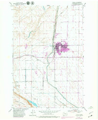
1954 Map of Othello
USGS Topo · Published 1979About this map
Chicago Milwaukee St Paul and Pacific tracks dominate the landscape of the Columbia Basin in this mid-century survey, anchoring the growing agricultural hub of Othello. The town's grid is defined by Main St and Broadway, serving as a central point for the surrounding farm blocks and irrigation infrastructure. The expansion of water management is evident through the massive East Low Canal and Potholes Canal, which are supported by a complex network including a siphon, flumes, and the Pumping Sta.
Find a feature on this map
36 named features on this map. Tap any name to fly to it.
Don’t see what you’re looking for? This feature index may not catch every label — zoom into the map to look around manually.
Map Details
Editions of this 1954 Othello Map
2 editions found

Other maps of this area

1923 · Corfu
USGS Topo · 1:62,500

1924 · Othello
USGS Topo · 1:62,500

1924 · Hanford
USGS Topo · 1:62,500

1925 · Scooteney Lake
USGS Topo · 1:62,500

1951 · Scooteney Lake
USGS Topo · 1:62,500

1951 · Corfu
USGS Topo · 1:62,500

1951 · Hanford
USGS Topo · 1:62,500

1953 · Walla Walla
USGS Topo · 1:250,000

1954 · Bruce
USGS Topo · 1:24,000

1954 · Warden
USGS Topo · 1:24,000