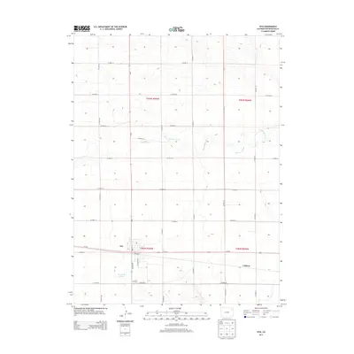
2013 Map of Otis
USGS Topo · Published 2013About this map
Otis serves as the primary hub of this eastern Colorado plains landscape, situated along the strategic corridor of Us-34 E. The map reveals a highly structured agricultural grid defined by numerous county roads, such as CO Road 46 and CO Road 40, which facilitate movement across the vast township divisions of t003n r050w and t002n r050w. Genealogists and local historians can locate the Otis Cem south of the town center, near the intersection of Co-61 and CO Road 39. The drainage patterns of the high plains are marked by the winding course of Surveyor Creek and the presence of Haverland Pond west of the main settlement. Small communities like Calhoun appear on the eastern edge of the survey, illustrating the dispersed nature of homesteading and transport in Washington County during this era.
Find a feature on this map
30 named features on this map. Tap any name to fly to it.
Don’t see what you’re looking for? This feature index may not catch every label — zoom into the map to look around manually.
Map Details
Editions of this 2013 Otis Map
This is the sole edition of this map. No revisions or reprints were ever made.
Other maps of this area

1954 · Sterling
USGS Topo · 1:250,000

1958 · Sterling
USGS Topo · 1:250,000
1972 · Otis
USGS Topo · 1:24,000
1972 · Hyde
USGS Topo · 1:24,000
1972 · Lone Star
USGS Topo · 1:24,000
1972 · Snyder Lake
USGS Topo · 1:24,000
1972 · Otis SE
USGS Topo · 1:24,000
1972 · Burdett
USGS Topo · 1:24,000
1973 · Platner
USGS Topo · 1:24,000
1973 · Buffalo Springs Ranch SE
USGS Topo · 1:24,000