
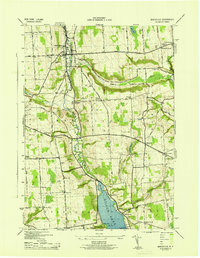
1943 Map of Otisco Valley
USGS Topo · Published 1943About this map
Otisco Lake defines the western edge of this wartime survey, which details the rugged glacial topography between the Otisco and Tully townships. The landscape is marked by steep ravines and waterfalls, including Fellows Falls and Bucktail Falls, as well as a series of kettle lakes to the east such as Song Lake, Crooked Lake, and Tully Lake. Industrial history is represented by the Salt Wells located in the valley near the Onondaga Creek headwaters. Genealogical interest is high throughout the rural uplands, with numerous numbered school districts like Dutch Hill Sch and School No 11 serving small crossroads settlements. This 1943 edition, produced under the direction of the Corps of Engineers, preserves the locations of numerous family-named cemeteries, including St Patricks Cem and the Hillsdale Cem, before modern land use altered the local character.
Find a feature on this map
70 named features on this map. Tap any name to fly to it.
Don’t see what you’re looking for? This feature index may not catch every label — zoom into the map to look around manually.
Map Details
Editions of this 1943 Otisco Valley Map
This is the sole edition of this map. No revisions or reprints were ever made.
Other maps of this area

1898 · Moravia
USGS Topo · 1:62,500

1899 · Skaneateles
USGS Topo · 1:62,500

1900 · Tully
USGS Topo · 1:62,500

1902 · Skaneateles
USGS Topo · 1:62,500

1902 · Moravia
USGS Topo · 1:62,500

1903 · Cortland
USGS Topo · 1:62,500

1943 · South Onondaga
USGS Topo · 1:31,680

1943 · Spafford
USGS Topo · 1:31,680

1943 · Jamesville
USGS Topo · 1:31,680
1943 · Marcellus
USGS Topo · 1:31,680