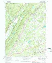
1969 Map of Otisville
USGS Topo · Published 1979About this map
The Shawangunk Mountains dominate this 1969 topographic survey of western Orange County, creating a sharp natural divide between the Basher Kill valley to the west and the rolling farmland to the east. The Erie-Lackawanna Railroad cuts through the terrain, passing through Otisville and skirting the foothills near Cuddebackville. This period of the late 1960s captures the region's diverse land use, from the institutional presence of the State Training School for Boys and a Sanitarium near Otisville to the recreational landscape of Birch Ridge Camp.
Find a feature on this map
65 named features on this map. Tap any name to fly to it.
Don’t see what you’re looking for? This feature index may not catch every label — zoom into the map to look around manually.
Map Details
Editions of this 1969 Otisville Map
2 editions found
Other maps of this area

1904 · Ellenville
USGS Topo · 1:62,500

1906 · Ellenville
USGS Topo · 1:62,500

1906 · Port Jervis
USGS Topo · 1:62,500

1906 · Goshen
USGS Topo · 1:62,500

1908 · Goshen
USGS Topo · 1:62,500

1908 · Port Jervis
USGS Topo · 1:62,500

1909 · Monticello
USGS Topo · 1:62,500

1911 · Monticello
USGS Topo · 1:62,500

1938 · Goshen
USGS Topo · 1:62,500

1942 · Pine Island
USGS Topo · 1:24,000