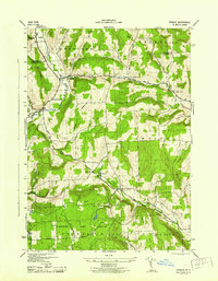
1944 Map of Otselic
USGS Topo · Published 1944About this map
The Otselic River valley serves as the central artery for this rural interior of Central New York, where the Madison Co Chenango Co border divides the township of Georgetown from the heart of Otselic. The landscape is defined by its numerous small school districts, such as School No 2 and School No 14, reflecting a traditional decentralized rural community structure still intact during the 1940s. These schools, alongside cemeteries like Maple Grove Cem and Cole Hill Cem, provide critical anchors for genealogists tracing family locations across the hills of Pharsalia and Smyrna.
Find a feature on this map
32 named features on this map. Tap any name to fly to it.
Don’t see what you’re looking for? This feature index may not catch every label — zoom into the map to look around manually.
Map Details
Editions of this 1944 Otselic Map
This is the sole edition of this map. No revisions or reprints were ever made.
Other maps of this area

1897 · Cazenovia
USGS Topo · 1:62,500

1899 · Cazenovia
USGS Topo · 1:62,500

1902 · Morrisville
USGS Topo · 1:62,500

1903 · Norwich
USGS Topo · 1:62,500

1904 · Pitcher
USGS Topo · 1:62,500

1943 · Otselic
USGS Topo · 1:24,000

1943 · West Eaton
USGS Topo · 1:24,000

1943 · South Ostelic
USGS Topo · 1:24,000
1943 · Erieville
USGS Topo · 1:24,000

1943 · Norwich
USGS Topo · 1:24,000