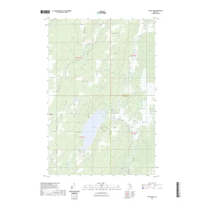
2023 Map of Otter Lake
USGS Topo · Published 2023About this map
Otter Lake dominates the central landscape of this Upper Peninsula survey, where the Houghton Co and Baraga Co border meets. The region is defined by a dense network of watercourses, including the Otter River, Sturgeon River, and Pike River, which carve through the timbered terrain. Small residential clusters and family-named roads reflect the area's deep-rooted rural character, with settlements like Tapiola and Hanka serving as local anchors. Genealogists will find significant value in the documentation of local burial grounds such as Kargi Cem and Askel Cem, located near the intersection of Cemetery Rd. The map also traces various named creeks, including Ebers Creek and Worham Creek, which feed into the larger river systems and Mud Lake. This detailed topographical record illustrates the persistent rural infrastructure of the Copper Country's southern reaches, from the crossroads at Niemi to the southern edge near Helberg.
Find a feature on this map
60 named features on this map. Tap any name to fly to it.
Don’t see what you’re looking for? This feature index may not catch every label — zoom into the map to look around manually.
Map Details
Editions of this 2023 Otter Lake Map
This is the sole edition of this map. No revisions or reprints were ever made.
Other maps of this area

1915 · Houghton
USGS Topo · 1:62,500

1946 · Chassell
USGS Topo · 1:24,000

1946 · South Range
USGS Topo · 1:24,000

1948 · South Range
USGS Topo · 1:24,000

1948 · Chassell
USGS Topo · 1:24,000

1954 · Keweenaw Bay
USGS Topo · 1:62,500

1954 · Point Mills
USGS Topo · 1:24,000

1954 · Pelkie
USGS Topo · 1:62,500

1954 · Houghton
USGS Topo · 1:62,500

1958 · Hancock
USGS Topo · 1:250,000