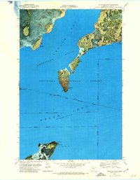
1971 Map of Ottertail Point
USGS Topo · Published 1974About this map
Sucker Bay and the northern reaches of Leech Lake dominate this 1970s orthophotomap, which utilizes high-altitude aerial photography to detail the complex shoreline of Cass County. This specific cartographic style emphasizes the dense forest cover and wetland transitions of the Chippewa National Forest and Bowstring State Forest. The map is characterized by significant administrative overlaps, showing the Leech Lake Indian Reservation Boundary as it bisects the open water and timberlands. Prominent landforms such as Ottertail Point and Hardwood Point reach into the basin, while the Stony Point Campground serves as a primary point of human activity on the southern shore. The technical data notes a normal reservoir pool elevation of 1296 feet, reflecting the managed water levels of this massive glacial lake system.
Find a feature on this map
15 named features on this map. Tap any name to fly to it.
Don’t see what you’re looking for? This feature index may not catch every label — zoom into the map to look around manually.
Map Details
Editions of this 1971 Ottertail Point Map
This is the sole edition of this map. No revisions or reprints were ever made.
Other maps of this area

1954 · Bemidji
USGS Topo · 1:250,000

1957 · Bemidji
USGS Topo · 1:250,000

1958 · Bemidji
USGS Topo · 1:250,000
1971 · Jack Lake
USGS Topo · 1:24,000
1971 · Whipholt
USGS Topo · 1:24,000

1971 · Sucker Lakes
USGS Topo · 1:24,000

1971 · Portage Lake
USGS Topo · 1:24,000
1971 · Sugar Point
USGS Topo · 1:24,000

1972 · Steamboat Bay
USGS Topo · 1:24,000

1972 · Pike Bay
USGS Topo · 1:24,000