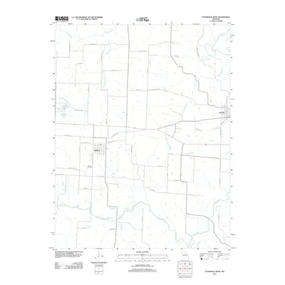
2011 Map of Otterville West
USGS Topo · Published 2011About this map
Smithton sits at a crossroads of rural transit and local history in this modern survey of the Missouri landscape. The town plan is clearly defined near the Smithton Cemetery, while the surrounding terrain is etched by an intricate network of watercourses including Flat Creek and the Lamine River. A particularly evocative feature for local history enthusiasts is the presence of Butterfield Stage Rd, a label that preserves the memory of 19th-century overland mail routes within the contemporary road grid. Small water bodies like Monsees Lake and Hermora Lake break up the agricultural parcels, while numerous named branches like Harlan Branch and Long Branch feed into the larger river systems. The map captures a transition where traditional named roads like Butterfield Stage Rd meet modern developments, providing a detailed record of land use and drainage patterns in Pettis County.
Find a feature on this map
54 named features on this map. Tap any name to fly to it.
Don’t see what you’re looking for? This feature index may not catch every label — zoom into the map to look around manually.
Map Details
Editions of this 2011 Otterville West Map
This is the sole edition of this map. No revisions or reprints were ever made.
Other maps of this area

1887 · Sedalia
USGS Topo · 1:125,000

1888 · Boonville
USGS Topo · 1:125,000

1894 · Sedalia
USGS Topo · 1:125,000

1944 · Sedalia East
USGS Topo · 1:24,000

1946 · Sedalia East
USGS Topo · 1:24,000

1947 · Jefferson City
USGS Topo · 1:250,000

1953 · Pilot Grove South
USGS Topo · 1:24,000
1953 · Florence
USGS Topo · 1:24,000
1953 · Otterville East
USGS Topo · 1:24,000
1953 · Clifton City
USGS Topo · 1:24,000