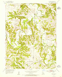
1953 Map of Clifton City
USGS Topo · Published 1955About this map
Clifton City sits at the junction of rail and river in the early 1950s, where the Missouri Kansas Texas railroad follows the winding banks of the Lamine River. This rural landscape on the border of Pettis and Cooper counties is defined by its small upland settlements and the creek branches that feed into the larger river system. Local life is anchored by family-named landmarks and rural institutions, from the Lamine Ch to several small burial grounds like Sowers Cem and Irving Cem.
Find a feature on this map
30 named features on this map. Tap any name to fly to it.
Don’t see what you’re looking for? This feature index may not catch every label — zoom into the map to look around manually.
Map Details
Editions of this 1953 Clifton City Map
2 editions found
Other maps of this area

1887 · Sedalia
USGS Topo · 1:125,000

1888 · Boonville
USGS Topo · 1:125,000

1894 · Sedalia
USGS Topo · 1:125,000

1944 · Sedalia East
USGS Topo · 1:24,000

1946 · Sedalia East
USGS Topo · 1:24,000

1947 · Jefferson City
USGS Topo · 1:250,000

1953 · Pilot Grove North
USGS Topo · 1:24,000

1953 · Pilot Grove South
USGS Topo · 1:24,000
1953 · Otterville East
USGS Topo · 1:24,000
1953 · Nelson
USGS Topo · 1:24,000