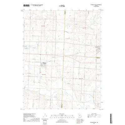
2017 Map of Otterville West
USGS Topo · Published 2017About this map
Smithton serves as the primary hub in this central Missouri landscape, where the town layout is clearly defined alongside the Smithton Cem. The geography is defined by a high concentration of watercourses and minor drainages, including Flat Creek, Lake Creek, and the headwaters of the Lamine River in the northeast. The transport network reflects a transition from historic overland routes to modern access, most notably preserved in the name of Butterfield Stage RD, which cuts across the northern half of the survey. Small impoundments like Hermosa Lake and Monsees Lake dot the western reaches, while the Pettis, Cooper, and Morgan county lines intersect in the southeast, creating a complex border area. Rural life is anchored by a grid of named roads like White School RD and Rattlesnake Hill RD, which trace the high ground between the various creek branches.
Find a feature on this map
53 named features on this map. Tap any name to fly to it.
Don’t see what you’re looking for? This feature index may not catch every label — zoom into the map to look around manually.
Map Details
Editions of this 2017 Otterville West Map
This is the sole edition of this map. No revisions or reprints were ever made.
Other maps of this area

1887 · Sedalia
USGS Topo · 1:125,000

1888 · Boonville
USGS Topo · 1:125,000

1894 · Sedalia
USGS Topo · 1:125,000

1944 · Sedalia East
USGS Topo · 1:24,000

1946 · Sedalia East
USGS Topo · 1:24,000

1947 · Jefferson City
USGS Topo · 1:250,000

1953 · Pilot Grove South
USGS Topo · 1:24,000
1953 · Florence
USGS Topo · 1:24,000
1953 · Otterville East
USGS Topo · 1:24,000
1953 · Clifton City
USGS Topo · 1:24,000