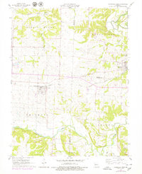
1960 Map of Otterville West
USGS Topo · Published 1979About this map
Smithton and Otterville anchor this western Pettis County landscape as it appeared in the mid-20th century. The Missouri Pacific railroad cuts a straight east-west path through the center of the sheet, serving as the primary corridor for commerce and settlement. Local social and spiritual life is marked by several community landmarks, including Providence Ch in the north and Bethlehem Ch in the southeast.
Find a feature on this map
26 named features on this map. Tap any name to fly to it.
Don’t see what you’re looking for? This feature index may not catch every label — zoom into the map to look around manually.
Map Details
Editions of this 1960 Otterville West Map
This is the sole edition of this map. No revisions or reprints were ever made.
Other maps of this area

1887 · Sedalia
USGS Topo · 1:125,000

1888 · Boonville
USGS Topo · 1:125,000

1894 · Sedalia
USGS Topo · 1:125,000

1944 · Sedalia East
USGS Topo · 1:24,000

1946 · Sedalia East
USGS Topo · 1:24,000

1947 · Jefferson City
USGS Topo · 1:250,000

1953 · Pilot Grove South
USGS Topo · 1:24,000
1953 · Florence
USGS Topo · 1:24,000
1953 · Otterville East
USGS Topo · 1:24,000
1953 · Clifton City
USGS Topo · 1:24,000