1951 Map of Otto
USGS Topo · Published 1953About this map
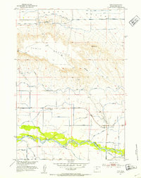
The Greybull River valley serves as the central artery for this 1951 topographic survey of Big Horn County, where a sophisticated network of irrigation sustains the high desert landscape. The town of Otto is the primary settlement, situated just north of the river near the confluence of the Wood and Burnett ditch system and the Farmers Canal. This intricate web of water management, including the Highline Ditch and the North Lateral Bench Canal, illustrates the region’s intensive transition to irrigated agriculture during the mid-century era.
Find a feature on this map
21 named features on this map. Tap any name to fly to it.
Don’t see what you’re looking for? This feature index may not catch every label — zoom into the map to look around manually.
Map Details
Editions of this 1951 Otto Map
2 editions found
Historical Maps of Otto Through Time
303 maps found

1898 Bald Mountain
Big Horn County, WY

1899 Cloud peak
Big Horn County, WY

1901 Bald Mountain
Big Horn County, WY

1901 Cloud peak
Big Horn County, WY

1951 Dutch Nick Flat NW
Big Horn County, WY

1951 Otto
Big Horn County, WY

1951 Schuster Flats NE
Big Horn County, WY

1951 Schuster Flats NW
Big Horn County, WY

1951 Sheep Mountain
Big Horn County, WY

1951 Sucker Dam
Big Horn County, WY

1951 Tatman Mountain
Big Horn County, WY

1951 Wardel Reservoir
Big Horn County, WY

1951 Y U Bench NE
Big Horn County, WY

1960 Bear Creek Ranch
Big Horn County, WY

1960 Black Mountain
Big Horn County, WY

1960 Bush Butte
Big Horn County, WY

1960 Devils Kitchen
Big Horn County, WY

1960 Flitner Reservoir
Big Horn County, WY

1960 Hidden Tepee Creek
Big Horn County, WY

1960 Hyatt Ranch
Big Horn County, WY

1960 Lake Solitude
Big Horn County, WY

1960 Leavitt Reservoir
Big Horn County, WY

1960 Manderson NE
Big Horn County, WY

1960 Manderson SE
Big Horn County, WY

1960 Medicine Wheel
Big Horn County, WY

1960 Mexican Hill
Big Horn County, WY

1960 Shell Falls
Big Horn County, WY

1960 Shell Lake
Big Horn County, WY

1960 Spanish Point
Big Horn County, WY

1960 White Sulphur Spring
Big Horn County, WY

1960 Wild Horse Flats
Big Horn County, WY

1964 Kane
Big Horn County, WY

1964 Lovell Lakes
Big Horn County, WY

1964 Natural Trap Cave
Big Horn County, WY

1964 Shell Reservoir
Big Horn County, WY

1964 Simmons Canyon
Big Horn County, WY

1964 Sykes Spring
Big Horn County, WY

1966 Alkali Creek
Big Horn County, WY

1966 Cottonwood Canyon
Big Horn County, WY

1966 Emblem SE
Big Horn County, WY

1966 Gilmore Hill NE
Big Horn County, WY

1966 Gilmore Hill SE
Big Horn County, WY

1966 Gould Butte
Big Horn County, WY

1966 Greybull North
Big Horn County, WY

1966 Greybull South
Big Horn County, WY

1966 Jack Horner Reservoir
Big Horn County, WY

1966 Jones Reservoir
Big Horn County, WY

1966 North Emblem Reservoir
Big Horn County, WY

1966 Orchard Bench
Big Horn County, WY

1966 Sheep Canyon
Big Horn County, WY

1966 Spence
Big Horn County, WY

1967 Brokenback Narrows
Big Horn County, WY

1967 Emblem
Big Horn County, WY

1967 Lake Helen
Big Horn County, WY

1967 Mc Dermotts Butte
Big Horn County, WY

1967 Meadowlark Lake
Big Horn County, WY

1967 Pierce Draw
Big Horn County, WY

1967 Rairden
Big Horn County, WY

1967 Weintz Draw
Big Horn County, WY

1993 Allen Draw
Big Horn County, WY

1993 Bear Creek Ranch
Big Horn County, WY

1993 Black Mountain
Big Horn County, WY

1993 Brokenback Narrows
Big Horn County, WY

1993 Cottonwood Canyon
Big Horn County, WY

1993 Hidden Tepee Creek
Big Horn County, WY

1993 Lake Helen
Big Horn County, WY

1993 Lake Solitude
Big Horn County, WY

1993 Leavitt Reservoir
Big Horn County, WY

1993 Meadowlark Lake
Big Horn County, WY

1993 Medicine Wheel
Big Horn County, WY

1993 Mexican Hill
Big Horn County, WY

1993 Shell Falls
Big Horn County, WY

1993 Shell Lake
Big Horn County, WY

1993 Shell Reservoir
Big Horn County, WY

1993 Spanish Point
Big Horn County, WY

2011 Natural Trap Cave
Big Horn County, WY

2011 Simmons Canyon
Big Horn County, WY

2011 Sykes Spring
Big Horn County, WY

2012 Alkali Creek
Big Horn County, WY

2012 Allen Draw
Big Horn County, WY

2012 Bear Creek Ranch
Big Horn County, WY

2012 Black Mountain
Big Horn County, WY

2012 Brokenback Narrows
Big Horn County, WY

2012 Bush Butte
Big Horn County, WY

2012 Cottonwood Canyon
Big Horn County, WY

2012 Devils Kitchen
Big Horn County, WY

2012 Dutch Nick Flat NW
Big Horn County, WY

2012 Emblem
Big Horn County, WY

2012 Emblem SE
Big Horn County, WY

2012 Flitner Reservoir
Big Horn County, WY

2012 Gilmore Hill NE
Big Horn County, WY

2012 Gilmore Hill SE
Big Horn County, WY

2012 Gould Butte
Big Horn County, WY

2012 Greybull North
Big Horn County, WY

2012 Greybull South
Big Horn County, WY

2012 Hidden Tepee Creek
Big Horn County, WY

2012 Hyatt Ranch
Big Horn County, WY

2012 Jack Horner Reservoir
Big Horn County, WY

2012 Jones Reservoir
Big Horn County, WY

2012 Kane
Big Horn County, WY

2012 Lake Helen
Big Horn County, WY

2012 Lake Solitude
Big Horn County, WY

2012 Leavitt Reservoir
Big Horn County, WY

2012 Lovell Lakes
Big Horn County, WY

2012 Manderson NE
Big Horn County, WY

2012 Manderson SE
Big Horn County, WY

2012 McDermotts Butte
Big Horn County, WY

2012 Meadowlark Lake
Big Horn County, WY

2012 Medicine Wheel
Big Horn County, WY

2012 Mexican Hill
Big Horn County, WY

2012 Natural Trap Cave
Big Horn County, WY

2012 North Emblem Reservoir
Big Horn County, WY

2012 Orchard Bench
Big Horn County, WY

2012 Otto
Big Horn County, WY

2012 Pierce Draw
Big Horn County, WY

2012 Rairden
Big Horn County, WY

2012 Schuster Flats NE
Big Horn County, WY

2012 Schuster Flats NW
Big Horn County, WY

2012 Sheep Canyon
Big Horn County, WY

2012 Sheep Mountain
Big Horn County, WY

2012 Shell Falls
Big Horn County, WY

2012 Shell Lake
Big Horn County, WY

2012 Shell Reservoir
Big Horn County, WY

2012 Simmons Canyon
Big Horn County, WY

2012 Spanish Point
Big Horn County, WY

2012 Spence
Big Horn County, WY

2012 Sucker Dam
Big Horn County, WY

2012 Sykes Spring
Big Horn County, WY

2012 Tatman Mountain
Big Horn County, WY

2012 Wardel Reservoir
Big Horn County, WY

2012 Weintz Draw
Big Horn County, WY

2012 White Sulphur Spring
Big Horn County, WY

2012 Wild Horse Flats
Big Horn County, WY

2012 Y U Bench NE
Big Horn County, WY

2015 Alkali Creek
Big Horn County, WY

2015 Allen Draw
Big Horn County, WY

2015 Bear Creek Ranch
Big Horn County, WY

2015 Black Mountain
Big Horn County, WY

2015 Brokenback Narrows
Big Horn County, WY

2015 Bush Butte
Big Horn County, WY

2015 Cottonwood Canyon
Big Horn County, WY

2015 Devils Kitchen
Big Horn County, WY

2015 Dutch Nick Flat NW
Big Horn County, WY

2015 Emblem
Big Horn County, WY

2015 Emblem SE
Big Horn County, WY

2015 Flitner Reservoir
Big Horn County, WY

2015 Gilmore Hill NE
Big Horn County, WY

2015 Gilmore Hill SE
Big Horn County, WY

2015 Gould Butte
Big Horn County, WY

2015 Greybull North
Big Horn County, WY

2015 Greybull South
Big Horn County, WY

2015 Hidden Tepee Creek
Big Horn County, WY

2015 Hyatt Ranch
Big Horn County, WY

2015 Jack Horner Reservoir
Big Horn County, WY

2015 Jones Reservoir
Big Horn County, WY

2015 Kane
Big Horn County, WY

2015 Lake Helen
Big Horn County, WY

2015 Lake Solitude
Big Horn County, WY

2015 Leavitt Reservoir
Big Horn County, WY

2015 Lovell Lakes
Big Horn County, WY

2015 Manderson NE
Big Horn County, WY

2015 Manderson SE
Big Horn County, WY

2015 McDermotts Butte
Big Horn County, WY

2015 Meadowlark Lake
Big Horn County, WY

2015 Medicine Wheel
Big Horn County, WY

2015 Mexican Hill
Big Horn County, WY

2015 Natural Trap Cave
Big Horn County, WY

2015 North Emblem Reservoir
Big Horn County, WY

2015 Orchard Bench
Big Horn County, WY

2015 Otto
Big Horn County, WY

2015 Pierce Draw
Big Horn County, WY

2015 Rairden
Big Horn County, WY

2015 Schuster Flats NE
Big Horn County, WY

2015 Schuster Flats NW
Big Horn County, WY

2015 Sheep Canyon
Big Horn County, WY

2015 Sheep Mountain
Big Horn County, WY

2015 Shell Falls
Big Horn County, WY

2015 Shell Lake
Big Horn County, WY

2015 Shell Reservoir
Big Horn County, WY

2015 Simmons Canyon
Big Horn County, WY

2015 Spanish Point
Big Horn County, WY

2015 Spence
Big Horn County, WY

2015 Sucker Dam
Big Horn County, WY

2015 Sykes Spring
Big Horn County, WY

2015 Tatman Mountain
Big Horn County, WY

2015 Wardel Reservoir
Big Horn County, WY

2015 Weintz Draw
Big Horn County, WY

2015 White Sulphur Spring
Big Horn County, WY

2015 Wild Horse Flats
Big Horn County, WY

2015 Y U Bench NE
Big Horn County, WY

2017 Alkali Creek
Big Horn County, WY

2017 Black Mountain
Big Horn County, WY

2017 Brokenback Narrows
Big Horn County, WY

2017 Bush Butte
Big Horn County, WY

2017 Cottonwood Canyon
Big Horn County, WY

2017 Devils Kitchen
Big Horn County, WY

2017 Dutch Nick Flat NW
Big Horn County, WY

2017 Emblem
Big Horn County, WY

2017 Emblem SE
Big Horn County, WY

2017 Flitner Reservoir
Big Horn County, WY

2017 Gilmore Hill NE
Big Horn County, WY

2017 Gilmore Hill SE
Big Horn County, WY

2017 Gould Butte
Big Horn County, WY

2017 Greybull North
Big Horn County, WY

2017 Greybull South
Big Horn County, WY

2017 Hidden Tepee Creek
Big Horn County, WY

2017 Hyatt Ranch
Big Horn County, WY

2017 Jack Horner Reservoir
Big Horn County, WY

2017 Jones Reservoir
Big Horn County, WY

2017 Kane
Big Horn County, WY

2017 Lake Solitude
Big Horn County, WY

2017 Leavitt Reservoir
Big Horn County, WY

2017 Lovell Lakes
Big Horn County, WY

2017 Manderson NE
Big Horn County, WY

2017 Manderson SE
Big Horn County, WY

2017 McDermotts Butte
Big Horn County, WY

2017 Medicine Wheel
Big Horn County, WY

2017 Mexican Hill
Big Horn County, WY

2017 Natural Trap Cave
Big Horn County, WY

2017 North Emblem Reservoir
Big Horn County, WY

2017 Orchard Bench
Big Horn County, WY

2017 Otto
Big Horn County, WY

2017 Pierce Draw
Big Horn County, WY

2017 Schuster Flats NE
Big Horn County, WY

2017 Schuster Flats NW
Big Horn County, WY

2017 Sheep Canyon
Big Horn County, WY

2017 Sheep Mountain
Big Horn County, WY

2017 Shell Lake
Big Horn County, WY

2017 Simmons Canyon
Big Horn County, WY

2017 Spanish Point
Big Horn County, WY

2017 Spence
Big Horn County, WY

2017 Sucker Dam
Big Horn County, WY

2017 Sykes Spring
Big Horn County, WY

2017 Tatman Mountain
Big Horn County, WY

2017 Wardel Reservoir
Big Horn County, WY

2017 Weintz Draw
Big Horn County, WY

2017 White Sulphur Spring
Big Horn County, WY

2017 Wild Horse Flats
Big Horn County, WY

2017 Y U Bench NE
Big Horn County, WY

2018 Allen Draw
Big Horn County, WY

2018 Bear Creek Ranch
Big Horn County, WY

2018 Lake Helen
Big Horn County, WY

2018 Meadowlark Lake
Big Horn County, WY

2018 Rairden
Big Horn County, WY

2018 Shell Falls
Big Horn County, WY

2018 Shell Reservoir
Big Horn County, WY

2021 Alkali Creek
Big Horn County, WY

2021 Allen Draw
Big Horn County, WY

2021 Bear Creek Ranch
Big Horn County, WY

2021 Black Mountain
Big Horn County, WY

2021 Brokenback Narrows
Big Horn County, WY

2021 Bush Butte
Big Horn County, WY

2021 Cottonwood Canyon
Big Horn County, WY

2021 Devils Kitchen
Big Horn County, WY

2021 Dutch Nick Flat NW
Big Horn County, WY

2021 Emblem
Big Horn County, WY

2021 Emblem SE
Big Horn County, WY

2021 Flitner Reservoir
Big Horn County, WY

2021 Gilmore Hill NE
Big Horn County, WY

2021 Gilmore Hill SE
Big Horn County, WY

2021 Gould Butte
Big Horn County, WY

2021 Greybull North
Big Horn County, WY

2021 Greybull South
Big Horn County, WY

2021 Hidden Tepee Creek
Big Horn County, WY

2021 Hyatt Ranch
Big Horn County, WY

2021 Jack Horner Reservoir
Big Horn County, WY

2021 Jones Reservoir
Big Horn County, WY

2021 Kane
Big Horn County, WY

2021 Lake Helen
Big Horn County, WY

2021 Lake Solitude
Big Horn County, WY

2021 Leavitt Reservoir
Big Horn County, WY

2021 Lovell Lakes
Big Horn County, WY

2021 Manderson NE
Big Horn County, WY

2021 Manderson SE
Big Horn County, WY

2021 McDermotts Butte
Big Horn County, WY

2021 Meadowlark Lake
Big Horn County, WY

2021 Medicine Wheel
Big Horn County, WY

2021 Mexican Hill
Big Horn County, WY

2021 Natural Trap Cave
Big Horn County, WY

2021 North Emblem Reservoir
Big Horn County, WY

2021 Orchard Bench
Big Horn County, WY

2021 Otto
Big Horn County, WY

2021 Pierce Draw
Big Horn County, WY

2021 Rairden
Big Horn County, WY

2021 Schuster Flats NE
Big Horn County, WY

2021 Schuster Flats NW
Big Horn County, WY

2021 Sheep Canyon
Big Horn County, WY

2021 Sheep Mountain
Big Horn County, WY

2021 Shell Falls
Big Horn County, WY

2021 Shell Lake
Big Horn County, WY

2021 Shell Reservoir
Big Horn County, WY

2021 Simmons Canyon
Big Horn County, WY

2021 Spanish Point
Big Horn County, WY

2021 Spence
Big Horn County, WY

2021 Sucker Dam
Big Horn County, WY

2021 Sykes Spring
Big Horn County, WY

2021 Tatman Mountain
Big Horn County, WY

2021 Wardel Reservoir
Big Horn County, WY

2021 Weintz Draw
Big Horn County, WY

2021 White Sulphur Spring
Big Horn County, WY

2021 Wild Horse Flats
Big Horn County, WY

2021 Y U Bench NE
Big Horn County, WY

2023 Meadowlark Lake
Big Horn County, WY