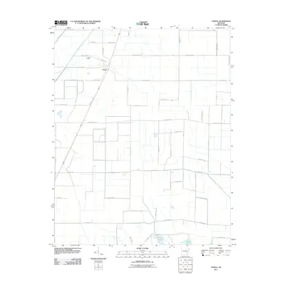
2011 Map of Otwell
USGS Topo · Published 2011About this map
Otwell serves as the central point of this Craighead County landscape, where agriculture and water management define the local geography. The area is heavily intersected by a network of drainage systems essential to the Delta region, including Caney Ditch, Raccoon Bayou, and the engineered course of Big Creek Lateral Number 1. These waterways feed into and surround the Claypool Reservoir at the southern edge of the quadrangle. For those researching local family history, the Otwell Cemetery is a primary landmark situated just north of the main settlement. The survey illustrates a rigid grid of rural corridors, with names like Punkin Center Rd and Dalton Farmer Dr reflecting the long-standing agricultural roots of the community. This topographic record documents the persistent intersection of natural bayous and human-made ditches that allows for the continued cultivation of this low-lying terrain.
Find a feature on this map
45 named features on this map. Tap any name to fly to it.
Don’t see what you’re looking for? This feature index may not catch every label — zoom into the map to look around manually.
Map Details
Editions of this 2011 Otwell Map
This is the sole edition of this map. No revisions or reprints were ever made.
Other maps of this area

1935 · Sedgwick
USGS Topo · 1:62,500

1939 · Weiner
USGS Topo · 1:62,500

1939 · Jonesboro
USGS Topo · 1:62,500

1940 · Dee
USGS Topo · 1:62,500

1953 · Memphis
USGS Topo · 1:250,000

1956 · Memphis
USGS Topo · 1:250,000

1958 · Dee
USGS Topo · 1:62,500

1958 · Jonesboro
USGS Topo · 1:62,500

1959 · Weiner
USGS Topo · 1:62,500

1959 · Sedgwick
USGS Topo · 1:62,500