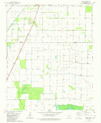
1980 Map of Otwell
USGS Topo · Published 1980About this map
The settlement of Otwell serves as the focal point of this 1980 survey, situated along the St Louis Southwestern railroad line at the border of Craighead and Poinsett counties. This landscape is defined by an extensive engineered irrigation and drainage network, including Big Creek Ditch, Whistle Ditch, and Pecan Ditch, which support the region's agricultural productivity. Local infrastructure is further evidenced by a Landing Strip and a Fish Hatchery located centrally in the quadrangle.
Find a feature on this map
15 named features on this map. Tap any name to fly to it.
Don’t see what you’re looking for? This feature index may not catch every label — zoom into the map to look around manually.
Map Details
Editions of this 1980 Otwell Map
This is the sole edition of this map. No revisions or reprints were ever made.
Other maps of this area

1935 · Sedgwick
USGS Topo · 1:62,500

1939 · Weiner
USGS Topo · 1:62,500

1939 · Jonesboro
USGS Topo · 1:62,500

1940 · Dee
USGS Topo · 1:62,500

1953 · Memphis
USGS Topo · 1:250,000

1956 · Memphis
USGS Topo · 1:250,000

1958 · Dee
USGS Topo · 1:62,500

1958 · Jonesboro
USGS Topo · 1:62,500

1959 · Weiner
USGS Topo · 1:62,500

1959 · Sedgwick
USGS Topo · 1:62,500