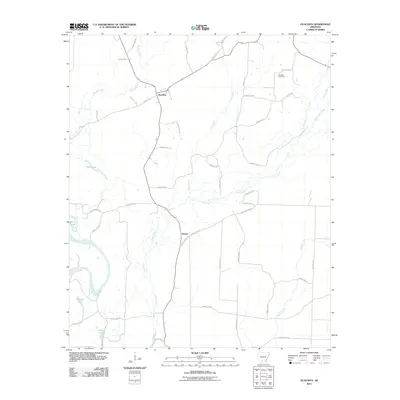
2011 Map of Ouachita
USGS Topo · Published 2011About this map
The Ouachita River winds through the southwestern corner of this Dallas County landscape, carving out a series of oxbows and wetlands including Georgia Lake, Utley Lake, and Bacon Lake. This riverine environment defines the lower portion of the map, while the northern reaches transition into a network of creek drainages. The small settlement of Ouachita sits at the intersection of several county routes, serving as a quiet focal point in a territory largely defined by timber and agriculture. To the south, Smead marks another point of settlement along the winding path of Tulip Creek. Local history is anchored by the Brazeale Cemetery to the northeast, while a complex system of forestry roads and county routes like Dallas 258 and Ouachita Road 86 provides access to the dense woodland between the larger waterways of Brushy Creek and Chapel Creek.
Find a feature on this map
47 named features on this map. Tap any name to fly to it.
Don’t see what you’re looking for? This feature index may not catch every label — zoom into the map to look around manually.
Map Details
Editions of this 2011 Ouachita Map
This is the sole edition of this map. No revisions or reprints were ever made.
Other maps of this area

1903 · Camden
USGS Topo · 1:125,000

1953 · El Dorado
USGS Topo · 1:250,000

1957 · El Dorado
USGS Topo · 1:250,000

1958 · El Dorado
USGS Topo · 1:250,000

1960 · El Dorado
USGS Topo · 1:250,000

1971 · Tates Bluff
USGS Topo · 1:24,000
1971 · Sparkman
USGS Topo · 1:24,000

1971 · Ouachita
USGS Topo · 1:24,000
1971 · Harmony Grove
USGS Topo · 1:24,000
1971 · Sparkman NW
USGS Topo · 1:24,000