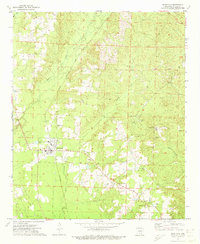
1971 Map of Sparkman
USGS Topo · Published 1973About this map
The Chicago and Rock Island Pacific railroad corridor anchors this survey of Dallas County, passing through the town of Sparkman as it cuts across the landscape. The settlement is centered on its grid and industrial features like the Sewage Disposal Pond, surrounded by a network of rural roads that connect smaller community hubs such as New Hope and Pine Grove. This 1971 map captures a region deeply rooted in its local history, evidenced by the high density of family and community burial grounds including Holeman Cem, Williams Cem, and Sparkman Cem. Elevated terrain at Koy Hill is marked by a Lookout Tower (KKP), providing a vantage point over the timbered drainages of Cypress Creek, Brushy Creek, and Horse Creek. Several country churches, such as Macedonia Ch and Mt Carmel Ch, further define the social geography of this Arkansas timberland area.
Find a feature on this map
29 named features on this map. Tap any name to fly to it.
Don’t see what you’re looking for? This feature index may not catch every label — zoom into the map to look around manually.
Map Details
Editions of this 1971 Sparkman Map
2 editions found
Other maps of this area

1903 · Camden
USGS Topo · 1:125,000

1953 · El Dorado
USGS Topo · 1:250,000

1955 · Little Rock
USGS Topo · 1:250,000

1956 · Little Rock
USGS Topo · 1:250,000

1957 · El Dorado
USGS Topo · 1:250,000

1958 · El Dorado
USGS Topo · 1:250,000

1960 · El Dorado
USGS Topo · 1:250,000

1960 · Little Rock
USGS Topo · 1:250,000

1964 · Little Rock
USGS Topo · 1:250,000
1965 · Dalark
USGS Topo · 1:24,000